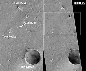
(A) Mars Pathfinder site, left: April 1998; right: January 2000.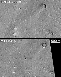
(B) top: April 1998; bottom: January 2000. |
Can Mars Global Surveyor's 1.5 meter (5 ft) per pixel camera be used to find any evidence as to the fate of the Mars Polar Lander that was lost on December 3, 1999? One way to find out is to look for one of the other Mars landers and determine what, if anything, can be seen. There have been three successful Mars lander missions: Viking 1 (July 1976), Viking 2 (September 1976), and Mars Pathfinder (July 1997). Of these, the location of Mars Pathfinder is known the best because there are several distinct landmarks visible in the lander's images that help in locating the spacecraft. The MGS MOC Operations Team at Malin Space Science Systems has been tasked since mid-December 1999 with looking for the lost Polar Lander. Part of this effort has been to test the capabilities of MOC by taking a picture of the landing site of Mars Pathfinder.
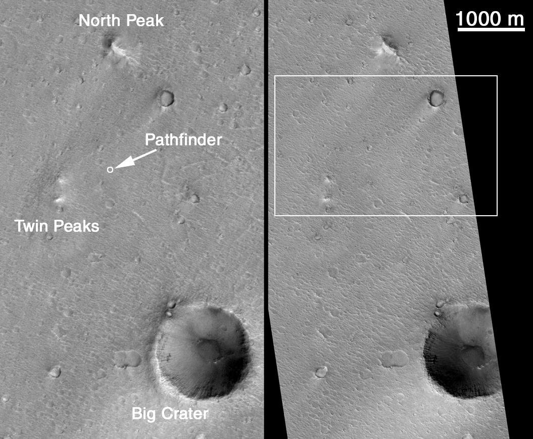
An attempt to photograph the Pathfinder site was made once before, in April 1998, by turning the entire MGS spacecraft so that the camera could point at the known location of the Mars Pathfinder lander. Turning the MGS spacecraft like this is not a normal operation -- it takes considerable planning, and disrupts the on-going, normal acquisition of science data. It took 3 attempts to succeed, but on April 22, 1998, MOC acquired the picture seen on the left side of Figure A, above. The three near-by major landmarks that were visible to the Pathfinder's cameras are labeled here (North Peak, Big Crater, Twin Peaks). It was known at the time that this image was not adequate to see the Pathfinder lander because the camera was not in focus and had a resolution of only 3.3 meters (11 ft) per pixel. In this and all other images shown here, north is up. All views of the 1998 MOC image are illuminated from the lower right, all views of the 2000 MOC image are illuminated from the lower left.
As part of the Polar Lander search effort, the Mars Pathfinder site was targeted again in December 1999 and January 2000. Like the 1998 attempt, the spacecraft had to be pointed off of its normal, nadir (straight-down) view. Like history repeating itself, it once again took 3 tries before the Pathfinder landing site was hit. The picture on the right side of Figure A, above, shows the new image that was acquired on January 16, 2000. The white box indicates the location shown in Figure B (above, right). The 1000 m scale bar equals 0.62 miles.
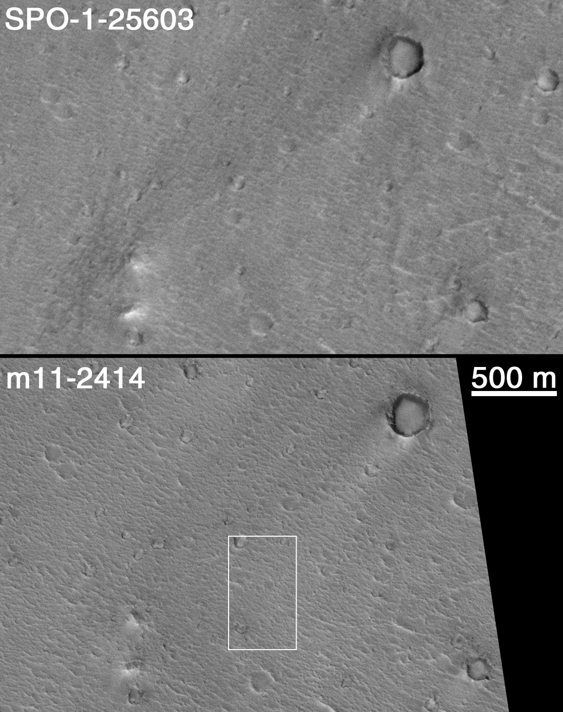
Figure B (above) shows a subsection of both the 1998 image (top, labeled SPO-1-25603) and the 2000 image (bottom, labeled m11-2414) projected at a scale of 3 meters (10 ft) per pixel. At this scale, the differences in camera focus and sunlight illumination angle are apparent, with the January 2000 image being both in focus and having better lighting conditions. In addition, the MGS spacecraft took the 2000 image from a lower altitude than in 1998, thus the image has better spatial resolution overall. The 500 m scale bar is equal to about 547 yards. The white box shows the location of images in Figure C, below.
(C) higher-resolution view; left: April 1998; right: January 2000. | 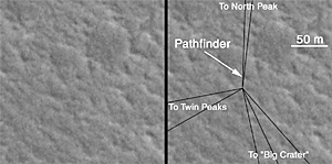
D) Erroneous, preliminary identification of Mars Pathfinder location in January 2000 image. Subsequent analysis (Figures E & F, below) identified the correct spot. |
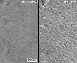
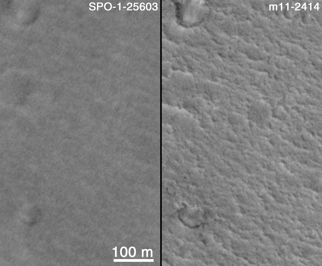
The third figure (C, above) again shows portions of the April 1998 image (C, left) and January 2000 image (C, right), only this time they have been enlarged to a resolution of 0.75 meters (2.5 ft) per pixel. The intrinsic resolution of the January 2000 image is 1.5 meters (5 ft), so this is a 200% expanded view of the actual M11-02414 image. The circular features in this and the previous images are impact craters in various states of erosion. Some boulders (dark dots) can be seen near the crater in the lower left corner. The texture that runs diagonally across the scene from upper left toward lower right consists of ridges created by the giant floods that washed through the Pathfinder site from Ares and/or Tiu Vallis many hundreds of millions of years ago. These ridges and the troughs between them were also seen by the Pathfinder lander; their crests often covered with boulders and cobbles (which cannot be seen at the resolution of the MOC image). The 100 m scale bar is equal to 109 yards (which can be compared with a 100 yard U.S. football field). The Mars Pathfinder landing site is located near the center of this view.The fourth picture, Figure D (above), shows a feature that was initially thought to be the Mars Pathfinder lander by MOC investigators. This and the following figures point out just how difficult it is to find a lander on the martian surface using the MGS MOC. Figure D was prepared early in the week following receipt of the new MOC image on January 17, 2000, and for several days it was believed that the lander had been found. As the subsequent two figures will show (E, and F, below), this location appears to be in error. How the features were misidentified is discussed below. Both Figure D and Figure F, showing possible locations of the Pathfinder lander in the MOC image, are enlarged by a factor of three over the intrinsic resolution of that image (that is, to a scale of 0.5 meters or about 1 ft, 7 inch per pixel). The right picture in Figure D shows sight-lines to the large horizon features -- Big Crater, Twin Peaks, and North Peak -- that were derived by the MOC team by looking at the images taken by the lander in 1997. After placing these lines on the overall image, there appeared to be two features close to the intersection of the sight-lines. Based upon the consistency of the size and shape of the lander as illuminated by sunlight in this image, the northern of the two candidate features (the small "hump" at the center of both left and right pictures) was considered, at the time, to be the most likely. HOWEVER...
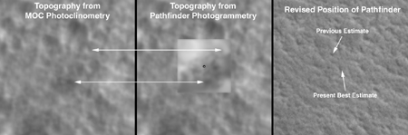
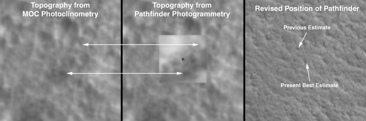
(E) Photoclinometry, Topography, and Revised Landing Site Location.
(F) Mars Pathfinder Landing Site; lander not resolved by MOC. |
Later in the week following acquisition of the January 16, 2000, image (and over the following weekend), there was time for additional analysis to determine whether the rounded hump identified earlier in the week (Figure D, above) was, in fact, the Mars Pathfinder lander. A computer program that estimates relative topography in a MOC image from knowledge of the illumination (called "shape-from-shading" or photoclinometry) was run to determine which parts of the landing site image are depressions, which are hills, and which are flat surfaces. The picture at the left in Figure E (above) shows the photoclinometry results for the area around the Pathfinder lander. The picture at the center of Figure E shows the same photoclinometry results overlain by an inset of a topographic map of the Pathfinder landing site derived by the U.S. Geological Survey Astrogeology Branch (Flagstaff, Arizona) from photogrammetry (parallax measurements) using images from Pathfinder's own stereo camera. By matching the features seen by MOC with those seen by the Pathfinder (the large arrows are examples of the matching), the location of the lander was refined and is now indicated in the picture on the right side of Figure E. The large, rounded hump previously identified as Pathfinder in Figure D (above), is more likely a large boulder that was seen in Pathfinder's images and named "Couch" by the Pathfinder science team in 1997.
Figure F is summary of the results of this effort to find Mars Pathfinder: it shows that while the landing site of Mars Pathfinder can be identified, the lander itself cannot be seen. It is too small to be resolved in an image where each pixel acquired by the MOC covers a square of 1.5 meters (5 feet) to a side, given the contrast conditions on Mars and the MOC's ability to discriminate contrast. At this scale, Pathfinder is not much larger than two pixels, and the same is true of the lost Polar Lander.
No evidence has been found in the January 2000 MOC image of the aft portion of Mars Pathfinder's aeroshell or its parachute, either. If the aeroshell is laying on its side, as interpreted from Mars Pathfinder's images, then it would be very difficult to see this from orbit. Because Pathfinder did not image the parachute, it is not known how it may be configured on the surface -- it could be wrapped around the aeroshell or a boulder, for example.
This effort to photograph the Mars Pathfinder lander demonstrates that it is extremely difficult to find a lander on the surface of Mars using the Mars Orbiter Camera aboard the MGS spacecraft. This analysis suggests that it is not very likely that the December 1999 Polar Lander will be found by MOC.


