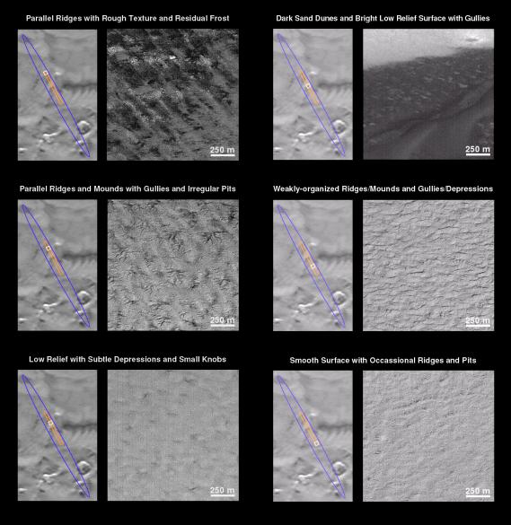
What is Mars Polar Lander going to find when it touches down on December 3rd? The Mars Global Surveyor (MGS) Mars Orbiter Camera (MOC) has been providing some spectacular previews. The following series of 7 figures illustrates the variety of surface textures, terrains, and geologic features that are found in the landing ellipse located at 76°S 195°W. It is now late southern spring, and the frost that covered this region for most of 1999 has gone away.
The focus here is upon a "tour" of a single MOC image obtained on November 26, 1999. In each figure below, the landing ellipse appears as a blue outline, the MOC image is drawn in orange, and the portion of the MOC image generally illustrated in each figure is yellow. The November 26th MOC image covers approximately 120 sq. km (75 sq. miles) of the central portion of the landing ellipse. The image is 3 km (1.9 mi) wide by 40 km (25 mi) long and has a resolution of about 4 meters (13 feet) per pixel. In each view, south is toward the top and the sun illuminates each scene from the lower right. The scale bar in each picture, 250 meters, is equal to 273 yards (820 ft).
Parallel Ridges with Rough Texture and Residual Frost
This picture shows a set of parallel ridges trending from upper left to lower right, spaced about 250-500 meters (273-547 yards) from one another. The amplitude of these ridges is not known, but elsewhere they are less than 20 m (66 ft) high. The surface also has irregular, light-toned knobs that resemble large boulders or pinnacles.
Parallel Ridges and Mounds with Gullies and Irregular Pits
A large portion of the landing ellipse (and the majority of the area seen in this image) is covered by parallel ridges surmounted by isolated groups of gullies and pits. The gully systems typically extend less than 500 meters (547 yards), and are often only a few hundred meters across. These gullies do not show the integration normal for fluid erosion (i.e., they were not carved by running water); instead, they have the form of cracks and depressions expanded by wall- and head-enlargement by processes such as sapping (removal of wall support by fluid seepage or the evaporation of ground ice) or ablation (removal of ices by sublimation and wind).
Low Relief with Subtle Depressions and Small Knobs
Some areas show little or no topographic relief (i.e., the area is relatively flat with no hills, ridges, or gullies). One class of this type of surface displays small, subtle, isolated depressions and areas of the rough texture made up of light-toned patches of knobs that resemble large boulders or pinnacles.
Dark Sand Dunes and Bright Low Relief Surface with Gullies
The darkest surface in the landing ellipse, now seen without its seasonal bright frost cover, shows the unmistakable form of dark sand dunes. This image shows the margin of the dune field that crosses the center of the MOC image. Note that in some places the sand depth is shallow and the shape and slopes of the underlying features can be seen.
Weakly-organized Ridges/Mounds and Gullies/Depressions
The second-most abundant surface texture in this portion of the landing ellipse consists of poorly aligned ridges and depressions which occasionally display steep wall slopes. This surface appears rugged at the scale of tens of meters, but may be smoother at small scales(meters).
Smooth Surface with Occasional Ridges and Pits
The southern-most portion of the November 26th MOC image shows a pattern of small, isolated ridges and a few irregular depressions and pits. However, much of the surface is actually quite smooth compared to other portions of the landing ellipse.
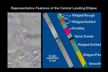
Representative Features of the Central Landing Ellipse
The illustration above shows a summary of the landforms seen within the November 26thMOC image in different colors. It is clear that the smoothest surface (green at bottom of frame) is rare in this part of the landing ellipse. Sand dunes (black) and really rough terrain (orange) are also fairly rare. Much of the surface is ridged with either gullies or pits.
 Planetary Data System


