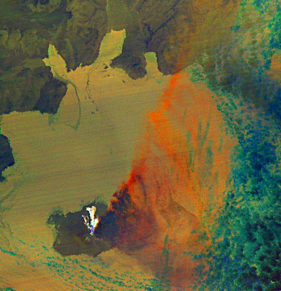
Since last spring, the U.S. Geological Survey's Alaska Volcano Observatory (AVO) has detected increasing volcanic unrest at Augustine Volcano in Cook Inlet, Alaska near Anchorage. Based on all available monitoring data, AVO regards that an eruption similar to 1976 and 1986 is the most probable outcome. During January, activity has been episodic, and characterized by emission of steam and ash plumes, rising to altitudes in excess of 9,000 m (30,000 ft), and posing hazards to aircraft in the vicinity. In the last week, volcanic flows have been seen on the volcano's flanks. An ASTER thermal image was acquired at night at 22:50 AST on January 31, 2006, during an eruptive phase of Augustine. The image shows three volcanic flows down the north flank of Augustine as white (hot) areas. The eruption plume spreads out to the east in a cone shape: it appears dark blue over the summit because it is cold and water ice dominates the composition; further downwind a change to orange color indicates that the plume is thinning and the signal is dominated by the presence of ash.
ASTER is one of five Earth-observing instruments launched December 18, 1999, on NASA's Terra satellite. The instrument was built by Japan's Ministry of Economy, Trade and Industry. A joint U.S./Japan science team is responsible for validation and calibration of the instrument and the data products.
The broad spectral coverage and high spectral resolution of ASTER provides scientists in numerous disciplines with critical information for surface mapping, and monitoring of dynamic conditions and temporal change. Example applications are: monitoring glacial advances and retreats; monitoring potentially active volcanoes; identifying crop stress; determining cloud morphology and physical properties; wetlands evaluation; thermal pollution monitoring; coral reef degradation; surface temperature mapping of soils and geology; and measuring surface heat balance.
The U.S. science team is located at NASA's Jet Propulsion Laboratory, Pasadena, Calif. The Terra mission is part of NASA's Science Mission Directorate.
Size: 54 by 51.9 km (33.5 by 32.1 miles)
Location: 59.3 deg. North latitude, 153.4 deg. West longitude
Orientation: north to top
Resolution: 90 m ASTER
Date Acquired: January 31, 2006
 Planetary Data System


