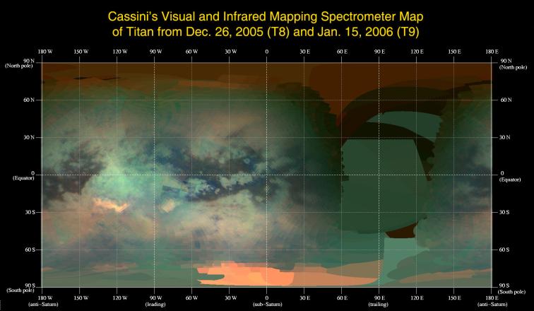
This global infrared map of Titan was composed with data from Cassini's visual and infrared mapping spectrometer taken during the last two Titan flybys, on Dec. 26, 2005, and Jan. 15, 2006.
The map was constructed from false-color images taken at wavelengths of 1.6 microns shown in blue, 2.01 microns in green, and 5 microns in red. All three images are of reflected sunlight.
The viewing geometry of the December flyby is roughly on the opposite hemisphere of the flyby in January. There are several important features to note in the map. First, the globe of Titan exhibits two major types of terrain, one is very bright, and a darker one seems to be concentrated near the equator. Titan also has two very bright regions, the large one known as Tui Reggio, located at approximately 25 degrees south latitude and 130 degrees west longitude, and the other as Hotei Arcus, at 20 degrees south latitude and 80 degrees west longitude. These regions are thought to be surface deposits, probably of volcanic origin, and may be water and/or carbon dioxide frozen from the volcanic vapor. The western margins of Tui Reggio have a complex flow-like structure consistent with eruptive phenomena. The reddish feature at the south pole is Titan's south polar cloud system, which was very bright during the December flyby. The impact crater Sinlap is clearly visible at approximately latitude 13 degrees north and longitude 16 degrees west. The poorly resolved regions between longitudes of 30 degrees and 150 degrees east will be filled in during subsequent flybys.
The Cassini-Huygens mission is a cooperative project of NASA, the European Space Agency and the Italian Space Agency. The Jet Propulsion Laboratory, a division of the California Institute of Technology in Pasadena, manages the mission for NASA's Science Mission Directorate, Washington, D.C. The Cassini orbiter was designed, developed and assembled at JPL. The visual and infrared mapping spectrometer team is based at the University of Arizona.
For more information about the Cassini-Huygens mission http://saturn.jpl.nasa.gov/home/index.cfm The visual and infrared mapping spectrometer team homepage is at http://wwwvims.lpl.arizona.edu.