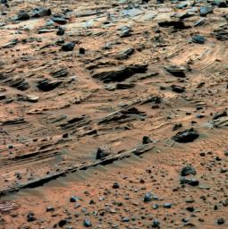
For the past several weeks, Spirit has been examining spectacular layered rocks exposed at "Home Plate." The rover has been driving around the northern and eastern edges of Home Plate, on the way to "McCool Hill." Before departing, Spirit took this image showing some of the most complex layering patterns seen so far at this location.
The layered nature of these rocks presents new questions for the rover team. In addition to their chemical properties, which scientists can study using Spirit's spectrometers, these rocks record a detailed history of the physical properties that formed them. In the center of this image, one group of layers slopes downward to the right. The layers above and below this group are more nearly horizontal. Where layers of different orientations intersect, other layers are truncated. This indicates that there were complex patterns of alternating erosion and deposition occurring when these layers were being deposited. Similar patterns can be found in some sedimentary rocks on Earth. Physical relationships among the various layers exposed at Home Plate are crucial evidence in understanding how these Martian rocks formed. Scientists suspect that the rocks at Home Plate were formed in the aftermath of a volcanic explosion or impact event, and they are investigating the possibility that wind may also have played a role in redistributing materials after such an event.
Images like this one from panoramic camera (Pancam), which shows larger-scale layering, as well as those from the microscopic imager, which reveal the individual sand-sized grains that make up these rocks, are essential to understanding the geologic history of Home Plate.
This view is a false-color rendering that combines separate images taken through the Pancam's 753-nanometer, 535-namometer, and 432-nanometer filters, enhanced to emphasize color differences among the rocks and soils. It was taken during Spirit's 774th Martian day (March 8, 2006).

 Planetary Data System


