PDS logoPlanetary Data System
PDS Information
Find a Node - Use these links to navigate to any of the 8 publicly accessible PDS Nodes.

This bar indicates that you are within the PDS enterprise which includes 6 science discipline nodes and 2 support nodes which are overseen by the Project Management Office at NASA's Goddard Space Flight Center (GSFC). Each node is led by an expert in the subject discipline, supported by an advisory group of other practitioners of that discipline, and subject to selection and approval under a regular NASA Research Announcement.
Click here to return to the Photojournal Home Page Click here to view a list of Photojournal Image Galleries Photojournal_inner_header
Latest Images  |  Spacecraft & Technology  |  Animations  |  Space Images App  |  Feedback  |  Photojournal Search  

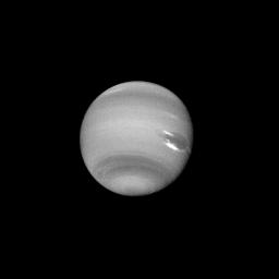
PIA01992: Neptune - Dark Feature
 Target Name:  Neptune
 Is a satellite of:  Sol (our sun)
 Mission:  Voyager
 Spacecraft:  Voyager 2
 Instrument:  VG ISS - Narrow Angle
 Product Size:  1000 x 1000 pixels (w x h)
 Produced By:  JPL
 Producer ID:  P34594
 Addition Date:  1999-07-25
 Primary Data Set:  Voyager EDRs
 Full-Res TIFF:  PIA01992.tif (137.6 kB)
 Full-Res JPEG:  PIA01992.jpg (33.24 kB)

Click on the image above to download a moderately sized image in JPEG format (possibly reduced in size from original)

Original Caption Released with Image:

This clear filter image was acquired by Voyager 2 on August 14, 1989, at a range of 14.8 million kilometers (9.2 million miles). The image shows a dark feature extending westward (left) and northward (up) toward the equator from the Great Dark Spot (GDS). This puzzling phenomenon developed over a relatively short period (three rotations or about 54 hours), and continues to evolve with time. Further study may reveal whether this protrusion represents an actual flow of dark cloud material from the GDS or is a result of atmospheric disturbances associated with the western boundary of the GDS. Bright, wispy "cirrus type" clouds are seen overlying the GDS at its southern (lower) margin and over its northwest (upper left) boundary. This is the first evidence that the GDS lies lower in the atmosphere than the bright clouds, which have remained in its vicinity for several months. Increasing detail in global banding and in the south polar region is also apparent. The Voyager Mission is conducted by the Jet Propulsion Laboratory for NASA's Office of Space Science and Applications.

Image Credit:
NASA/JPL

Image Addition Date:
1999-07-25