PDS logoPlanetary Data System
PDS Information
Find a Node - Use these links to navigate to any of the 8 publicly accessible PDS Nodes.

This bar indicates that you are within the PDS enterprise which includes 6 science discipline nodes and 2 support nodes which are overseen by the Project Management Office at NASA's Goddard Space Flight Center (GSFC). Each node is led by an expert in the subject discipline, supported by an advisory group of other practitioners of that discipline, and subject to selection and approval under a regular NASA Research Announcement.
Click here to return to the Photojournal Home Page Click here to view a list of Photojournal Image Galleries Photojournal_inner_header
Latest Images  |  Spacecraft & Technology  |  Animations  |  Space Images App  |  Feedback  |  Photojournal Search  

PIA01950: Surface of Enceladus
 Target Name:  Enceladus
 Is a satellite of:  Saturn
 Mission:  Voyager
 Spacecraft:  Voyager 2
 Instrument:  VG ISS - Narrow Angle
 Product Size:  450 x 469 pixels (w x h)
 Produced By:  JPL
 Producer ID:  P23943
 Addition Date:  1999-04-11
 Primary Data Set:  Voyager EDRs
 Full-Res TIFF:  PIA01950.tif (178 kB)
 Full-Res JPEG:  PIA01950.jpg (38.89 kB)

Click on the image above to download a moderately sized image in JPEG format (possibly reduced in size from original)

Original Caption Released with Image:

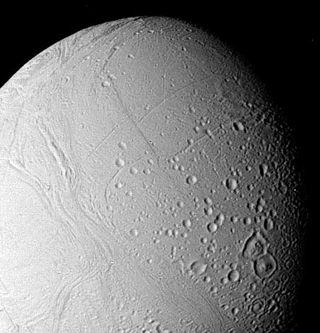
The surface of Enceladus is seen in this closeup view obtained Aug. 25, when Voyager 2 was 112,000 kilometers (69,500 miles) from this satellite of Saturn. This view, in which Enceladus north pole is toward the bottom right, shows the moon to bear a striking resemblance of Ganymede, the largest Galilean satellite of Jupiter. Moderately cratered areas have been transected by strips of younger grooved terrain. This more recently formed terrain--the light cratering says it must be relatively young--has consumed portions of craters such as those near the bottom center of this picture. This suggests that Enceladus has experienced internal melting even though it is only about 490 km. (300 mi.) in diameter. The grooves and linear features indicate that the satellite has been subjected to considerable crustal deformation as a result of this internal melting. The largest crater visible here is about 35 km. (20 mi.) across. The Voyager project is managed for NASA by the Jet Propulsion Laboratory, Pasadena, Calif.

Image Credit:
NASA/JPL

Image Addition Date:
1999-04-11