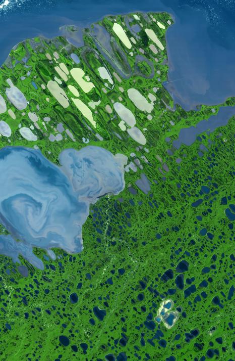
This ASTER image of Teshekpuk Lake on Alaska's North Slope, within the National Petroleum Reserve, was acquired on August 15, 2000. It covers an area of 58.7 x 89.9 km, and is centered near 70.4 degrees north latitude, 153 degrees west longitude.
With its 14 spectral bands from the visible to the thermal infrared wavelength region, and its high spatial resolution of 15 to 90 meters (about 50 to 300 feet), ASTER images Earth to map and monitor the changing surface of our planet.
ASTER is one of five Earth-observing instruments launched December 18, 1999, on NASA's Terra satellite. The instrument was built by Japan's Ministry of Economy, Trade and Industry. A joint U.S./Japan science team is responsible for validation and calibration of the instrument and the data products.
The broad spectral coverage and high spectral resolution of ASTER provides scientists in numerous disciplines with critical information for surface mapping, and monitoring of dynamic conditions and temporal change. Example applications are: monitoring glacial advances and retreats; monitoring potentially active volcanoes; identifying crop stress; determining cloud morphology and physical properties; wetlands evaluation; thermal pollution monitoring; coral reef degradation; surface temperature mapping of soils and geology; and measuring surface heat balance.
The U.S. science team is located at NASA's Jet Propulsion Laboratory, Pasadena, Calif. The Terra mission is part of NASA's Science Mission Directorate.
Size: 58.7 by 89.9 kilometers (36.4 by 55.7 miles)
Location: 70.4 degrees North latitude, 153 degrees West longitude
Orientation: North at top
Image Data: ASTER Bands 3, 2, and 1
Original Data Resolution: ASTER 30 meters (98.4 feet)
Dates Acquired: August 15, 2000