PDS logoPlanetary Data System
PDS Information
Find a Node - Use these links to navigate to any of the 8 publicly accessible PDS Nodes.

This bar indicates that you are within the PDS enterprise which includes 6 science discipline nodes and 2 support nodes which are overseen by the Project Management Office at NASA's Goddard Space Flight Center (GSFC). Each node is led by an expert in the subject discipline, supported by an advisory group of other practitioners of that discipline, and subject to selection and approval under a regular NASA Research Announcement.
Click here to return to the Photojournal Home Page Click here to view a list of Photojournal Image Galleries Photojournal_inner_header
Latest Images  |  Spacecraft & Technology  |  Animations  |  Space Images App  |  Feedback  |  Photojournal Search  

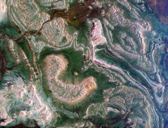
PIA01863: Space Radar Image of Eastern Morocco
 Target Name:  Earth
 Is a satellite of:  Sol (our sun)
 Mission:  Spaceborne Imaging Radar-C/X-Band Synthetic Aperture Radar 
 Spacecraft:  Space Shuttle
 Product Size:  3537 x 2708 pixels (w x h)
 Produced By:  JPL
 Producer ID:  P48663
 Addition Date:  1999-04-15
 Full-Res TIFF:  PIA01863.tif (35.28 MB)
 Full-Res JPEG:  PIA01863.jpg (3.031 MB)

Click on the image above to download a moderately sized image in JPEG format (possibly reduced in size from original)

Original Caption Released with Image:

This spaceborne radar image shows how the Atlas Mountains in northwestern Africa dominate the geography of Morocco. The image shows a part of the eastern flank of these mountains near the town of Rissani, approximately 50 kilometers (31 miles) from its border with Algeria. The striking bright patterns are the complex folds in the layered rocks of this region. Careful examination of the image shows areas where the folded structures have been disrupted due to fault movement and earthquakes. Dark areas between the rock outcrops are covered in sand and serve as channels for seasonal streams in this arid region. Scientists can use images like this one to map the geology and drainage patterns in arid regions.

The area shown is 44 kilometers by 34 kilometers (27 miles by 21 miles) centered at 31 degrees north latitude, 4.4 degrees west longitude; north is toward the upper right. Colors are assigned to different radar frequencies and polarizations as follows: red is L-band horizontally transmitted, horizontally received; green is C-band horizontally transmitted, horizontally received; blue is C-band horizontally transmitted, vertically received.

The image was acquired by the Spaceborne Imaging Radar-C/X-band Synthetic Aperture (SIR-C/X-SAR) imaging radar when it flew aboard the space shuttle Endeavour on April 15, 1994. SIR-C/X-SAR, a joint mission of the German, Italian and United States space agencies, is part of NASA's Mission to Planet Earth program.

Image Credit:
NASA/JPL

Image Addition Date:
1999-04-15