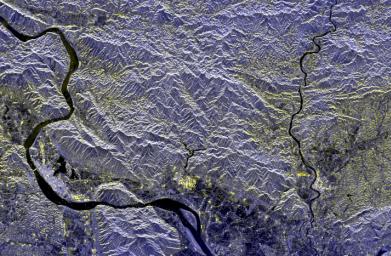
PIA01837: Space Radar Image of Mineral Resources, China
 Target Name:  Earth
 Is a satellite of:  Sol (our sun)
 Mission:  Spaceborne Imaging Radar-C/X-Band Synthetic Aperture Radar 
 Spacecraft:  Space Shuttle
 Product Size:  2325 x 1521 pixels (w x h)
 Produced By:  JPL
 Producer ID:  P46823
 Addition Date:  1999-04-15
 Full-Res TIFF:  PIA01837.tif (9.551 MB)
 Full-Res JPEG:  PIA01837.jpg (1.02 MB)

Click on the image above to download a moderately sized image in JPEG format (possibly reduced in size from original)

Original Caption Released with Image:

This spaceborne radar image of a mineral-rich region in southern China is being used by geologists to identify potential new areas for mineral exploration. The area shown is the vicinity of the city of Zhao Qing, the light blue area along the banks of the River Xi Jiang in the lower left. This is in the southern Chinese province of Guangdong, about 75 kilometers (46 miles) west of Guangzhou (Canton). The largest gold mine in southern China is located in the far upper left of the image along a brightly reflective mountain ridge. Using the radar image as a guide, geologists are tracing the extension of the ridge structure to the east (right) to identify possible mining areas. Radar imaging is especially useful for this purpose because of its sensitivity to subtle topographic structure, even in areas such as these, which have a dense vegetation cover. The Xi Jiang area is one of the most productive mining regions in China, with deposits of tungsten, lead, zinc and gold.

The image was acquired by the Spaceborne Imaging Radar-C/X-Band Synthetic Aperture Radar (SIR-C/X-SAR) onboard the space shuttleEndeavour on April 17, 1994. The image is centered at 37.2 degreesnorth latitude and 112.5 degrees east longitude. North is toward the upper right. The image shows an area 60 kilometers by 38 kilometers (37.2 miles by 23.6 miles) The colors are assigned to different frequencies and polarizations of the radar as follows: red is L-band, horizontally transmitted, horizontally received; green is L-band, horizontally transmitted, vertically received; blue is C-band, horizontally transmitted, vertically received. SIR-C/X-SAR, a joint mission of the German, Italian and United States space agencies, is part of NASA's Mission to Planet Earthprogram.

Image Credit:
NASA/JPL

Image Addition Date:
1999-04-15