- Original Caption Released with Image:
-
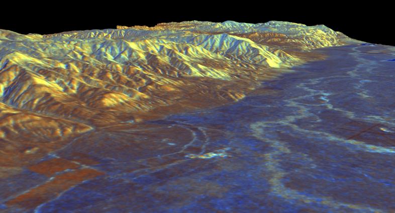
This is a three-dimensional perspective view of Owens Valley, near the town of Bishop, California that was created by combining two spaceborne radar images using a technique known as interferometry. Visualizations like this one are helpful to scientists because they clarify the relationships of the different types of surfaces detected by the radar and the shapes of the topographic features such as mountains and valleys. The view is looking southeast along the eastern edge of Owens Valley. The White Mountains are in the center of the image, and the Inyo Mountains loom in the background. The high peaks of the White Mountains rise more than 3,000 meters (10,000 feet) above the valley floor. The runways of the Bishop airport are visible at the right edge of the image. The meandering course of the Owens River and its tributaries appear light blue on the valley floor. Blue areas in the image are smooth, yellow areas are rock outcrops, and brown areas near the mountains are deposits of boulders, gravel and sand known as alluvial fans. The image was constructed by overlaying a color composite radar image on top of a digital elevation map.
The radar data were taken by the Spaceborne Imaging Radar-C/X-band Synthetic Aperture Radar (SIR-C/X-SAR) on board the space shuttle Endeavour in October 1994. The digital elevation map was produced using radar interferometry, a process in which radar data are acquired on different passes of the space shuttle. The two data passes are compared to obtain elevation information. The elevation data were derived from a 1,500-km-long (930-mile) digital topographic map processed at JPL. Radar image data are draped over the topography to provide the color with the following assignments: red is L-band vertically transmitted, vertically received; green is C-band vertically transmitted, vertically received; and blue is the ratio of C-band vertically transmitted, vertically received to L-band vertically transmitted, vertically received. This image is centered near 37.4 degrees north latitude and 118.3 degrees west longitude. No vertical exaggeration factor has been applied to the data. SIR-C/X-SAR, a joint mission of the German, Italian, and the United States space agencies, is part of NASA's Mission to Planet Earth.
- Image Credit:
-
NASA/JPL
Image Addition Date: -
1999-04-15
|