- Original Caption Released with Image:
-
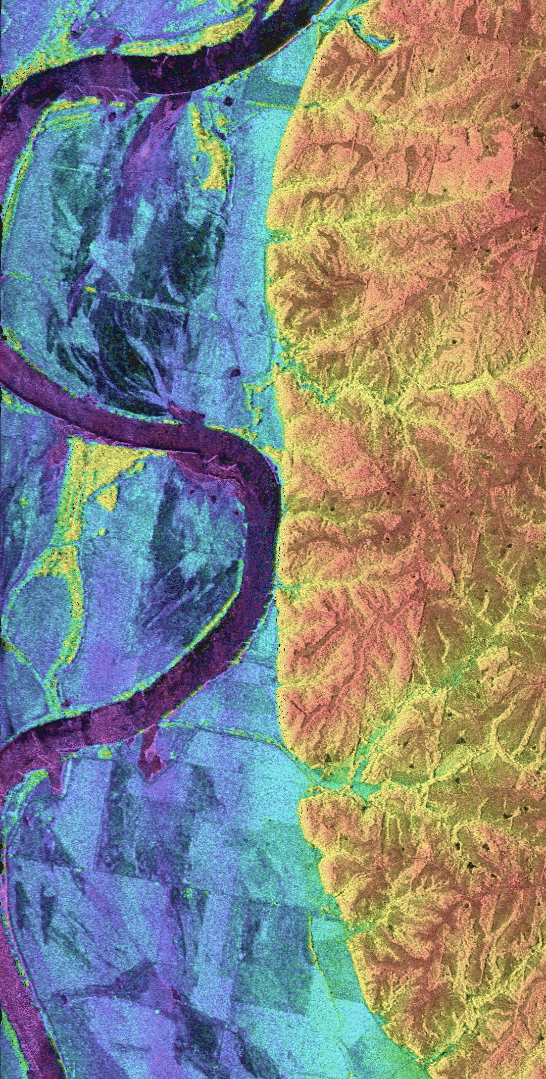
This is a combined radar and topography image of an area along the Missouri River that experienced severe flooding and levee failure in the summer of 1993. The meandering course of the Missouri River is seen as the dark curving band on the left side of the image. The predominantly blue area on the left half of the image is the river's floodplain, which was completely inundated during the flood of 1993. The colors in the image represent elevations, with the low areas shown in purple, intermediate areas in blue, green and yellow, and the highest areas shown in orange. The total elevation range is 85 meters (279 feet). The higher yellow and orange area on the right side of the image shows the topography and drainage patterns typical of this part of the midwestern United States. Dark streaks and bands in the floodplain are agricultural areas that were severely damaged by levee failures during the flooding. The region enclosed by the C-shaped bend in the river in the upper part of the image is Lisbon Bottoms. A powerful outburst of water from a failed levee on the north side of Lisbon Bottoms scoured a deep channel across the fields, which shows up as purple band. As the flood waters receded, deposits of sand and silt were left behind, which now appear as dark, smooth streaks in the image. The yellow areas within the blue, near the river, are clumps of trees sitting on slightly higher ground within the floodplain. The radar "sees" the treetops, and that is why they are so much higher (yellow) than the fields.
The image was acquired by the NASA/JPL Topographic Synthetic Aperture Radar system (TOPSAR) that flew over the area aboard a DC-8 aircraft in August 1994. The elevations are obtained by a technique known as radar interferometry, in which the radar signals are transmitted by one antenna, and echoes are received by two antennas aboard the aircraft. The two sets of received signals are combined using computer processing to produce a topographic map. Similar techniques can be used to map the Earth's topography from satellites and from the space shuttle. The brightness of the image represents the radar backscatter at C-band, in the vertically transmitted and received polarization. The image is centered south of the town of Glasgow in central Missouri, at 39.1 degrees north latitude and 92.9 degrees west longitude. The area shown is about 5 km by 10 km (3.1 by 6.2 miles). Radar and topography data such as these are being used by scientists to more accurately assess the potential for future flooding in this region and how that might impact surrounding communities. Radar and interferometry processing for this image was performed at JPL; image generation was performed at Washington University, St. Louis.
- Image Credit:
-
NASA/JPL
Image Addition Date: -
1999-04-15
|
