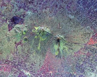
PIA01782: Space Radar Image of Central Java, Indonesia
 Target Name:  Earth
 Is a satellite of:  Sol (our sun)
 Mission:  Spaceborne Imaging Radar-C/X-Band Synthetic Aperture Radar 
 Spacecraft:  Space Shuttle
 Product Size:  4500 x 3600 pixels (w x h)
 Produced By:  JPL
 Producer ID:  P45750
 Addition Date:  1999-04-15
 Full-Res TIFF:  PIA01782.tif (63.05 MB)
 Full-Res JPEG:  PIA01782.jpg (5.97 MB)

Click on the image above to download a moderately sized image in JPEG format (possibly reduced in size from original)

Original Caption Released with Image:

The summits of two large volcanoes in Central Java, Indonesia are shown in the center of this radar image. Lava flows of different ages and surface roughness appear in shades of green and yellow surrounding the summit of Mt. Merbabu (mid-center) and Mt. Merapi (lower center). Mt. Merapi erupted on November 28, 1994 about six weeks after this image was taken. The eruption killed more than 60 people and forced the evacuation of more than 6,000 others. Thousands of other residents were put on alert due to the possibility of volcanic debris mudflows, called lahars, that threatened nearby towns. Mt. Merapi is located approximately 40 kilometers (25 miles) north of Yogyakarta, the capital of Central Java. The older volcano at the top of the image is unnamed. Lake Rawapening is the dark blue feature in the upper right. The light blue area southeast of the lake is the city of Salatiga. Directly south of Salatiga and southeast of Mt. Merapi is the city of Boyolali. Scientists are studying Mt. Merapi as part of the international "Decade Volcanoes" project, because of its recent activity and potential threat to local populations. The radar data are being used to identify and distinguish a variety of volcanic features.

This image was acquired on October 10, 1994 by the Spaceborne Imaging Radar-C/X-Band Synthetic Aperture Radar (SIR-C/X-SAR) aboard the space shuttle Endeavour. SIR-C/X-SAR, a joint mission of the German, Italian and the United States space agencies, is part of NASA's Mission to Planet Earth. The image is centered at 7.5 degrees South latitude and 110.5 degrees East longitude and covers an area of 33 kilometers by 65 kilometers (20 miles by 40 miles).

Image Credit:
NASA/JPL

Image Addition Date:
1999-04-15