- Original Caption Released with Image:
-
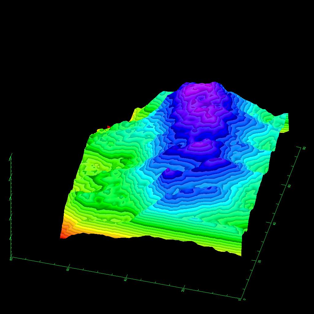
This three-dimensional image of the volcano Kilauea was generated based on interferometric fringes derived from two X-band Synthetic Aperture Radar data takes on April 13, 1994 and October 4, 1994. The altitude lines are based on quantitative interpolation of the topographic fringes. The level difference between neighboring altitude lines is 20 meters (66 feet). The ground area covers 12 kilometers by 4 kilometers (7.5 miles by 2.5 miles). The altitude difference in the image is about 500 meters (1,640 feet). The volcano is located around 19.58 degrees north latitude and 155.55 degrees west longitude.
Spaceborne Imaging Radar-C and X-band Synthetic Aperture Radar (SIR-C/X-SAR) is part of NASA's Mission to Planet Earth. The radars illuminate Earth with microwaves, allowing detailed observations at any time, regardless of weather or sunlight conditions. SIR-C/X-SAR uses three microwave wavelengths: L-band (24 cm), C-band (6 cm) and X-band (3 cm). The multi-frequency data will be used by the international scientific community to better understand the global environment and how it is changing. The SIR-C/X-SAR data, complemented by aircraft and ground studies, will give scientists clearer insights into those environmental changes which are caused by nature and those changes which are induced by human activity.
SIR-C was developed by NASA's Jet Propulsion Laboratory. X-SAR was developed by the Dornier and Alenia Spazio companies for the German space agency, Deutsche Agentur fuer Raumfahrtangelegenheiten (DARA), and the Italian space agency, Agenzia Spaziale Italiana (ASI), with the Deutsche Forschungsanstalt fuer Luft und Raumfahrt e.V.(DLR), the major partner in science, operations and data processing of X-SAR. The Instituto Ricerca Elettromagnetismo Componenti Elettronici (IRECE) at the University of Naples was a partner in the interferometry analysis.
- Image Credit:
-
NASA/JPL
Image Addition Date: -
1999-05-01
|
 Planetary Data System


