- Original Caption Released with Image:
-
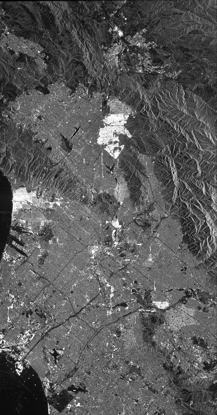
This is a radar image of Los Angeles, California, taken on October 2, 1994. Visible in the image are Long Beach Harbor at the bottom right (south corner of the image), Los Angeles International Airport at the bottom center, with Santa Monica just to the left of it and the Hollywood Hills to the left of Santa Monica. Also visible in the image are the freeway systems of Los Angeles, which appear as dark lines. The San Gabriel Mountains (center top) and the communities of San Fernando Valley, Simi Valley and Palmdale can be seen on the left-hand side.
This image was acquired by the Spaceborne Imaging Radar-C and X-band Synthetic Aperture Radar (SIR-C/X-SAR) aboard the space shuttle Endeavour on its 24th orbit. The image is centered at 34 degrees north latitude, 118 degrees west longitude. The area shown is approximately 100 kilometers by 52 kilometers (62 miles by 32 miles). This single-frequency SIR-C image was obtained by the L-band (24 cm) radar channel, horizontally transmitted and received. Portions of the Pacific Ocean visible in this image appear very dark as do freeways and other flat surfaces such as the airport runways. Mountains in the image are dark grey, with brighter patches on the mountain slopes, which face in the direction of the radar illumination (from the top of the image). Suburban areas, with the low-density housing and tree-lined streets that are typical of Los Angeles, appear as lighter grey. Areas with high-rise buildings, such as downtown Los Angeles, appear in very bright white, showing a higher density of housing and streets which run parallel to the radar flight track. Scientists hope to use radar image data from SIR-C/X-SAR to map fire scars in areas prone to brush fires, such as Los Angeles. In this image, the Altadena fire area is visible in the top center of the image as a patch of mountainous terrain which is slightly darker than the nearby mountains. Using all the radar frequency and polarization images provided by SIR-C/X-SAR, scientists will be able to discern these areas even more clearly.
Space Imaging Radar-C and X-band Synthetic Aperture Radar (SIR-C/X-SAR) is part of NASA's Mission to Planet Earth. The radars illuminate Earth with microwaves allowing detailed observations at any time, regardless of weather or sunlight conditions. SIR-C/X-SAR uses three microwave wavelengths: the L-band (24 cm), C-band (6 cm) and X-band (3 cm). The multi-frequency data will be used by the international scientific community to better understand the global environment and how it is changing. The SIR-C/X-SAR data, complemented by aircraft and ground studies, will give scientists clearer insights into those environmental changes which are caused by nature and those changes which are induced by human activity.
SIR-C was developed by NASA's Jet Propulsion Laboratory. X-SAR was developed by the Dornier and Alenia Spazio companies for the German space agency, Deutsche Agentur fuer Raumfahrtangelegenheiten (DARA), and the Italian space agency, Agenzia Spaziale Italiana (ASI), with the Deutsche Forschungsanstalt fuer Luft und Raumfahrt e.V.(DLR), the major partner in science, operations and data processing of X-SAR.
- Image Credit:
-
NASA/JPL
Image Addition Date: -
1999-05-01
|
