- Original Caption Released with Image:
-
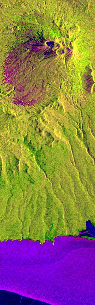
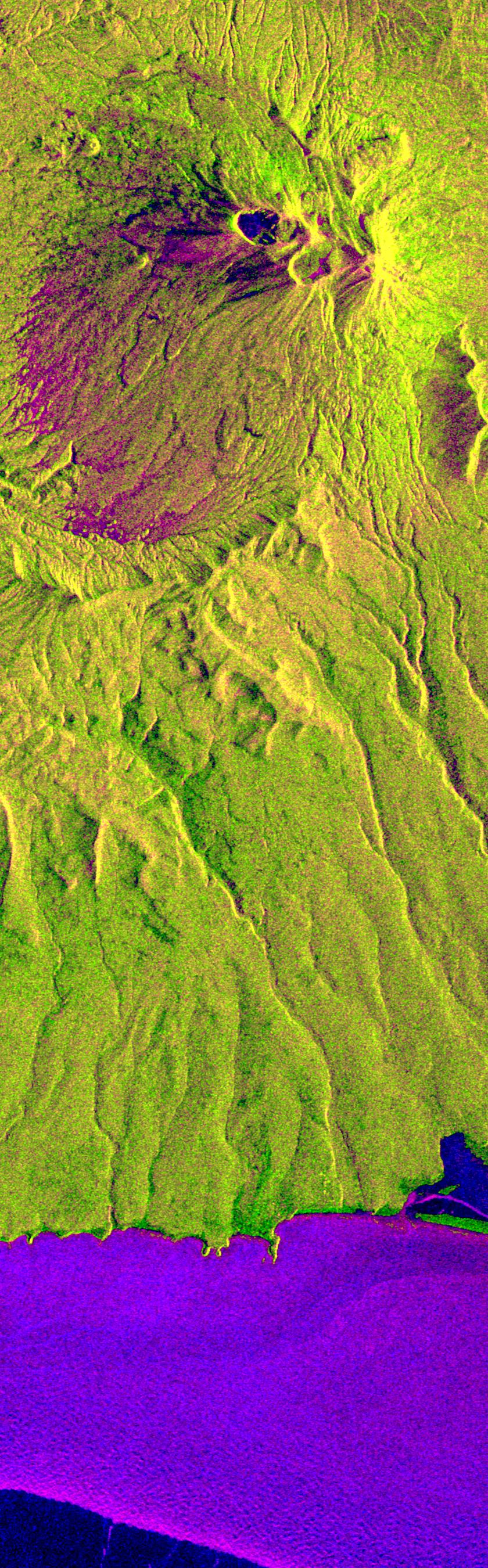
This is an X-band seasonal image of the Maly Semlyachik volcano, which is part of the Karymsky volcano group on Kamchatka peninsula, Russia. The image is centered at 54.2 degrees north latitude and 159.6 degrees east longitude. This image was acquired by the Spaceborne Imaging Radar-C and X-band Synthetic Aperture Radar (SIR-C/X-SAR) aboard the space shuttle Endeavour on April 9, 1994, during the first flight of the radar system, and on September 30, 1994, during the second flight.
The image channels have been assigned the following colors: red corresponds to data acquired on April 9; green corresponds to data acquired on September 30; and blue corresponds to the ratio between data from April 9 and September 30, 1994.
Kamchatka is twice as large as England, Scotland and Wales combined and is home to approximately 470,000 residents. The region is characterized by a chain of volcanoes stretching 800 kilometers (500 miles) across the countryside. Many of the volcanoes, including the active Maly Semlyachik volcano in this image, have erupted during this century. But the most active period in creating the three characteristic craters of this volcano goes back 20,000, 12,000 and 2,000 years ago. The highest summit of the oldest crater reaches about 1,560 meters (1,650 feet). The radar images reveal the geological structures of craters and lava flows in order to improve scientists' knowledge of these sometimes vigorously active volcanoes. This seasonal composite also highlights the ecological differences that have occurred between April and October 1994. In April the whole area was snow-covered and, at the coast, an ice sheet extended approximately 5 kilometers (3 miles) into the sea. The area shown surrounding the volcano is covered by low vegetation much like scrub. Kamchatka also has extensive forests, which belong to the northern frontier of Taiga, the boreal forest ecosystem. This region plays an important role in the world's carbon cycle. Trees require 60 years to mature in Kamchatka's 120-day growing season. The forest industry is managing these forests and practicing selective cutting to allow younger trees time to grow and reseed. X-SAR images will aid in mapping these deforested areas and in encouraging further recultivation efforts.
Spaceborne Imaging Radar-C and X-band Synthetic Aperture Radar (SIR-C/X-SAR) is part of NASA's Mission to Planet Earth. The radars illuminate Earth with microwaves, allowing detailed observations at any time, regardless of weather or sunlight conditions. SIR-C/X-SAR uses three microwave wavelengths: L-band (24 cm), C-band (6 cm) and X-band (3 cm). The multi-frequency data will be used by the international scientific community to better understand the global environment and how it is changing. The SIR-C/X-SAR data, complemented by aircraft and ground studies, will give scientists clearer insights into those environmental changes which are caused by nature and those changes which are induced by human activity.
SIR-C was developed by NASA's Jet Propulsion Laboratory. X-SAR was developed by the Dornier and Alenia Spazio companies for the German space agency, Deutsche Agentur fuer Raumfahrtange-legenheiten (DARA), and the Italian space agency, Agenzia Spaziale Italiana (ASI), with the Deutsche Forschungsanstalt fuer Luft und Raumfahrt e.V.(DLR), the major partner in science, operations and data processing of X-SAR.
- Image Credit:
-
NASA/JPL
Image Addition Date: -
1999-05-01
|