- Original Caption Released with Image:
-
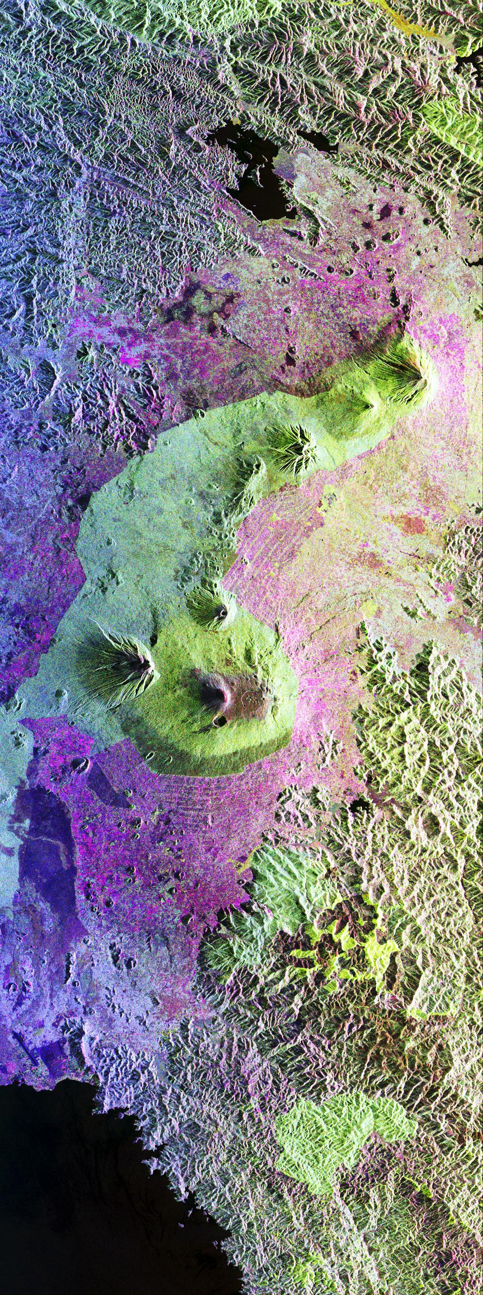
This is a false-color radar image of Central Africa, showing the Virunga Volcano chain along the borders of Rwanda, Zaire and Uganda. This area is home to the endangered mountain gorillas.
This C-band L-band image was acquired on April 12, 1994, on orbit 58 of space shuttle Endeavour by the Spaceborne Imaging Radar-C/X-band Synthetic Aperture Radar (SIR-C/X-SAR). The area is centered at about 1.75 degrees south latitude and 29.5 degrees east longitude. The image covers an area 58 kilometers by 178 kilometers (48 miles by 178 miles). The false-color composite is created by displaying the L-band HH return in red, the L-band HV return in green and the C-band HH return in blue. The dark area in the bottom of the image is Lake Kivu, which forms the border between Zaire (to the left) and Rwanda (to the right). The airport at Goma, Zaire is shown as a dark line just above the lake in the bottom left corner of the image. Volcanic flows from the 1977 eruption of Mt. Nyiragongo are shown just north of the airport. Mt. Nyiragongo is not visible in this image because it is located just to the left of the image swath. Very fluid lava flows from the 1977 eruption killed 70 people.
Mt. Nyiragongo is currently erupting (August 1994) and will be a target of observation during the second flight of SIR-C/X-SAR. The large volcano in the center of the image is Mt. Karisimbi (4,500 meters or 14,800 feet). This radar image highlights subtle differences in the vegetation and volcanic flows of the region. The faint lines shown in the purple regions are believed to be the result of agriculture terracing by the people who live in the region. The vegetation types are an important factor in the habitat of the endangered mountain gorillas.
Researchers at Rutgers University in New Jersey and the Dian Fossey Gorilla Fund in London will use this data to produce vegetation maps of the area to aid in their study of the remaining 650 gorillas in the region.
SIR-C was developed by NASA's Jet Propulsion Laboratory. X-SAR was developed by the Dornier and Alenia Spazio companies for the German space agency, Deutsche Agentur fuer Raumfahrtangelegenheiten (DARA), and the Italian space agency, Agenzia Spaziale Italiana (ASI), with the Deutsche Forschungsanstalt fuer Luft und Raumfahrt e.v. (DLR), the major partner in science, operations and data processing of X-SAR.
- Image Credit:
-
NASA/JPL-Caltech
Image Addition Date: -
1999-01-27
|
