- Original Caption Released with Image:
-
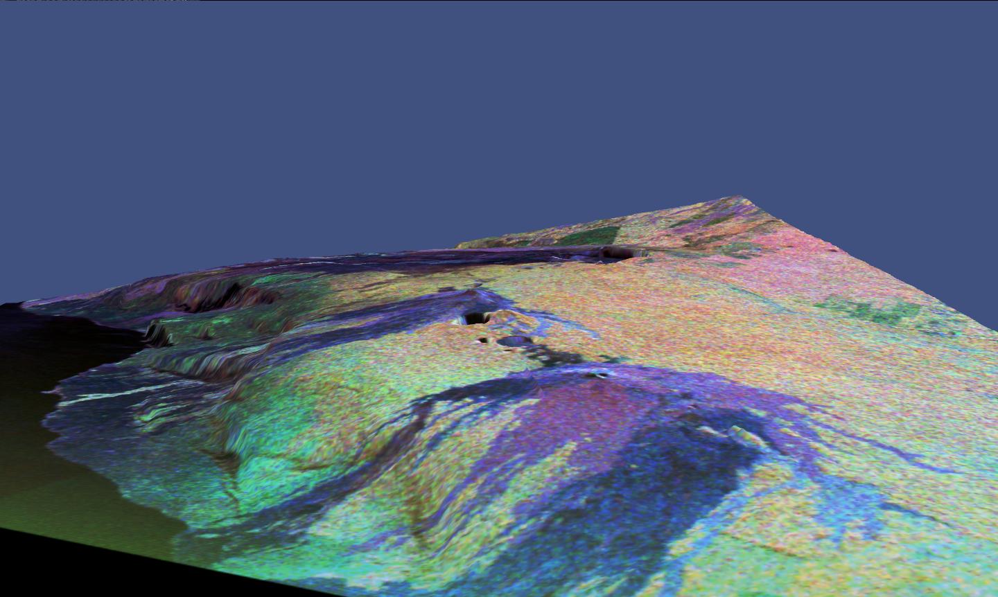
This is a three-dimensional perspective view of a false-color image of the eastern part of the Big Island of Hawaii. It was produced using all three radar frequencies -- X-band, C-band and L-band -- from the Spaceborne Imaging Radar-C/X-Band Synthetic Aperture Radar (SIR-C/X-SAR) flying on the space shuttle Endeavour, overlaid on a U.S. Geological Survey digital elevation map. Visible in the center of the image in blue are the summit crater (Kilauea Caldera) which contains the smaller Halemaumau Crater, and the line of collapse craters below them that form the Chain of Craters Road.
The image was acquired on April 12, 1994 during orbit 52 of the space shuttle. The area shown is approximately 34 by 57 kilometers (21 by 35 miles) with the top of the image pointing toward northwest. The image is centered at about 155.25 degrees west longitude and 19.5 degrees north latitude. The false colors are created by displaying three radar channels of different frequency. Red areas correspond to high backscatter at L-HV polarization, while green areas exhibit high backscatter at C-HV polarization. Finally, blue shows high return at X-VV polarization. Using this color scheme, the rain forest appears bright on the image, while the green areas correspond to lower vegetation. The lava flows have different colors depending on their types and are easily recognizable due to their shapes.
The flows at the top of the image originated from the Mauna Loa volcano. Kilauea volcano has been almost continuously active for more than the last 11 years. Field teams that were on the ground specifically to support these radar observations report that there was vigorous surface activity about 400 meters (one-quartermile) inland from the coast. A moving lava flow about 200 meters (650 feet) in length was observed at the time of the shuttle overflight, raising the possibility that subsequent images taken during this mission will show changes in the landscape. Currently, most of the lava that is erupted travels the 8 kilometers (5 miles) from the Pu'u O'o crater (the active vent) just outside this image to the coast through a series of lava tubes, but in the past there have been many large lava flows that have traveled this distance, destroying houses and parts of the Hawaii Volcanoes National Park.
This SIR-C/X-SAR image shows two types of lava flows that are common to Hawaiian volcanoes. Pahoehoe lava flows are relatively smooth, and appear very dark blue because much of the radar energy is reflected away from the radar. In contrast other lava flows are relatively rough and bounce much of the radar energy back to the radar, making that part of the image bright blue. This radar image is valuable because it allows scientists to study an evolving lava flow field from the Pu'u O'o vent. Much of the area on the northeast side (right) of the volcano is covered with tropical rain forest, and because trees reflect a lot of the radar energy, the forest appears bright in this radar scene. The linear feature running from Kilauea Crater to the right of the image is Highway 11leading to the city of Hilo which is located just beyond the right edge of this image.
Spaceborne Imaging Radar-C and X-Synthetic Aperture Radar (SIR-C/X-SAR) is part of NASA's Mission to Planet Earth. The radars illuminate Earth with microwaves allowing detailed observations at any time, regardless of weather or sunlight conditions. SIR-C/X-SAR uses three microwave wavelengths: L-band (24 cm), C-band (6 cm) and X-band (3 cm). The multi-frequency data will be used by the international scientific community to better understand the global environment and how it is changing. The SIR-C/X-SAR data, complemented by aircraft and ground studies, will give scientists clearer insights into those environmental changes which are caused by nature and those changes which are induced by human activity.
SIR-C was developed by NASA's Jet Propulsion Laboratory. X-SAR was developed by the Dornier and Alenia Spazio companies for the German space agency, Deutsche Agentur fuer Raumfahrtangelegenheiten (DARA), and the Italian space agency, Agenzia Spaziale Italiana (ASI), with the Deutsche Forschungsanstalt fuer Luft und Raumfahrte.v. (DLR), the major partner in science, operations and data processing of X-SAR.
- Image Credit:
-
NASA/JPL-Caltech
Image Addition Date: -
1999-01-27
|
