- Original Caption Released with Image:
-
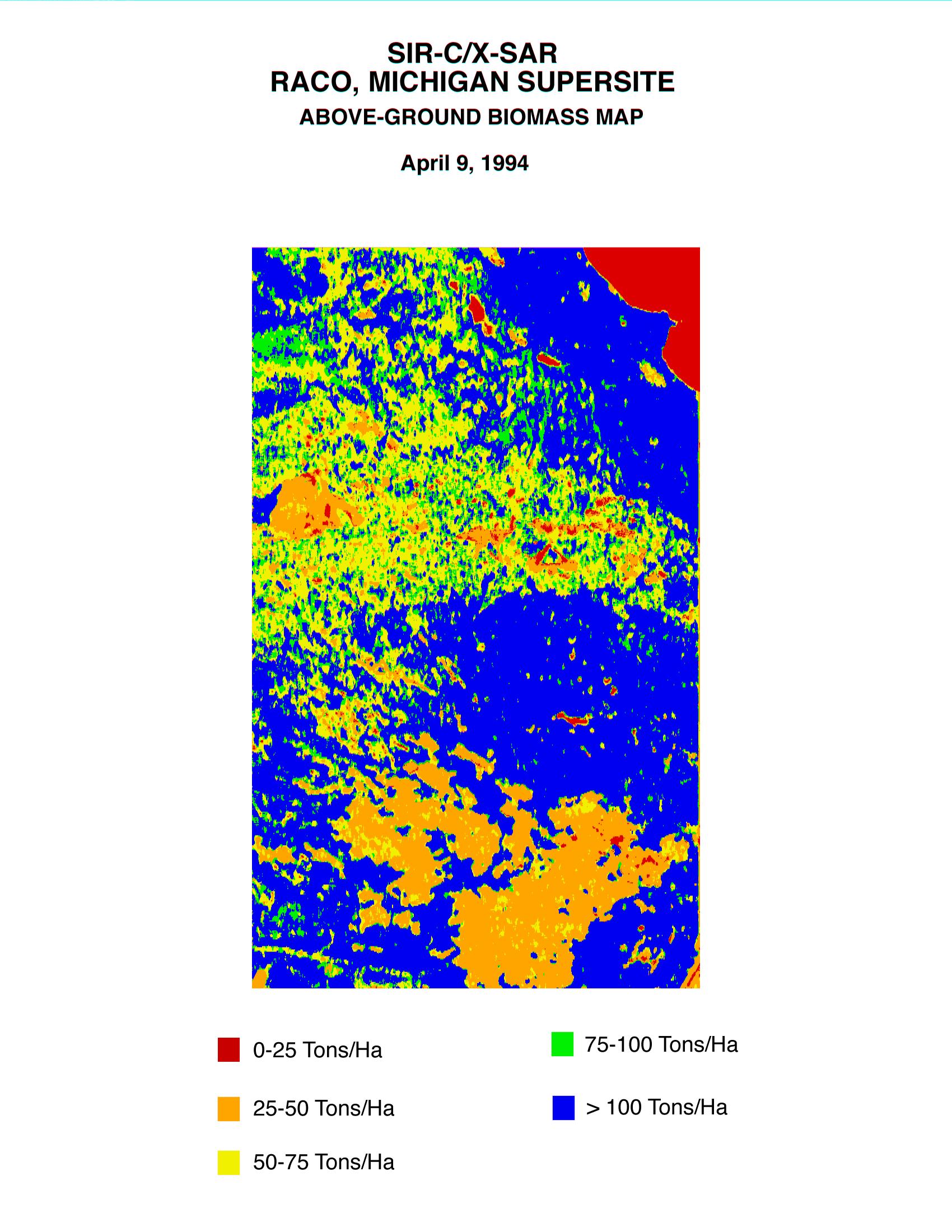
This biomass map of the Raco, Michigan, area was produced from data acquired by the Spaceborne Imaging Radar C/X-Band Synthetic Aperture Radar (SIR-C/X-SAR) onboard space shuttle Endeavour. Biomass is the amount of plant material on an area of Earth's surface. Radar can directly sense the quantity and organizational structure of the woody biomass in the forest.
Science team members at the University of Michigan used the radar data to estimate the standing biomass for this Raco site in the Upper Peninsula of Michigan. Detailed surveys of 70 forest stands will be used to assess the accuracy of these techniques. The seasonal growth of terrestrial plants, and forests in particular, leads to the temporary storage of large amounts of carbon, which could directly affect changes in global climate. In order to accurately predict future global change, scientists need detailed information about current distribution of vegetation types and the amount of biomass present around the globe. Optical techniques to determine net biomass are frustrated by chronic cloud-cover. Imaging radar can penetrate through cloud-cover with negligible signal losses.
Spaceborne Imaging Radar-C and X-Synthetic Aperture Radar (SIR-C/X-SAR) is part of NASA's Mission to Planet Earth. The radars illuminate Earth with microwaves allowing detailed observations at any time, regardless of weather or sunlight conditions. SIR-C/X-SAR uses three microwave wavelengths: L-band (24 cm), C-band (6 cm) and X-band (3 cm). The multi-frequency data will be used by the international scientific community to better understand the global environment and how it is changing. The SIR-C/X-SAR data, complemented by aircraft and ground studies, will give scientists clearer insights into those environmental changes which are caused by nature and those changes which are induced by human activity.
SIR-C was developed by NASA's Jet Propulsion Laboratory. X-SAR was developed by the Dornier and Alenia Spazio companies for the German space agency, Deutsche Agentur fuer Raumfahrtangelegenheiten (DARA), and the Italian space agency, Agenzia Spaziale Italiana (ASI), with the Deutsche Forschungsanstalt fuer Luft und Raumfahrt e.v. (DLR), the major partner in science, operations and data processing of X-SAR.
- Image Credit:
-
NASA/JPL-Caltech
Image Addition Date: -
1999-01-27
|
