- Original Caption Released with Image:
-
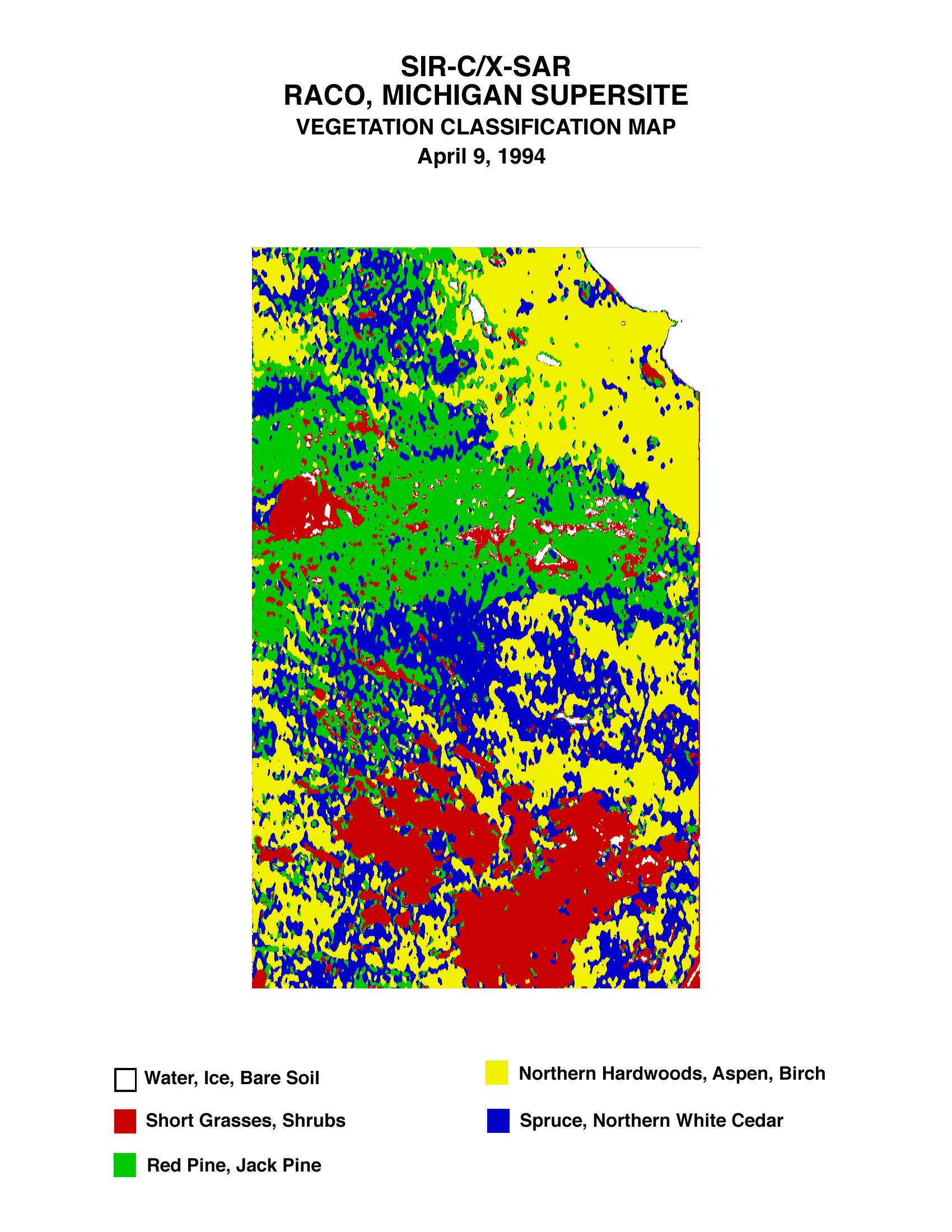
This is a vegetation map of the Raco, Michigan area produced from data acquired by the Spaceborne Imaging Radar C/X-Band Synthetic Aperture Radar (SIR-C/X-SAR) onboard space shuttle Endeavour. The radar image, taken on April 9, 1994, has been used by science team members at the University of Michigan to produce detailed map of land cover. This image is centered at 46.4 degrees north latitude and 84.9 degrees west longitude. The imaged area is approximately 24 by 32 kilometers (15 by 20 miles).
The Raco airport, which is a decommissioned military base, is easily identified by its triangular runway structure. An edge of Lake Superior, approximately 44 kilometers (27 miles) west of Sault Sainte Marie, appears in the top right of the image. In this land cover map each 30- by 30-meter (98- by 98-foot) spot is identified as either a water surface, bare ground, short vegetation, deciduous forest, lowland conifers or upland conifers. Different types of ground cover have different effects on Earth's chemical, water and energy cycles. By cataloguing ground cover in an area, scientists expect to better understand the processes of these cycles in a specific area.
Spaceborne Imaging Radar-C and X-Synthetic Aperture Radar (SIR-C/X-SAR) is part of NASA's Mission to Planet Earth. The radars illuminate Earth with microwaves allowing detailed observations at any time, regardless of weather or sunlight conditions. SIR-C/X-SAR uses three microwave wavelengths: L-band (24 cm), C-band (6 cm) and X-band (3 cm). The multi-frequency data will be used by the international scientific community to better understand the global environment and how it is changing. The SIR-C/X-SAR data, complemented by aircraft and ground studies, will give scientists clearer insights into those environmental changes which are caused by nature and those changes which are induced by human activity.
SIR-C was developed by NASA's Jet Propulsion Laboratory. X-SAR was developed by the Dornier and Alenia Spazio companies for the German space agency, Deutsche Agentur fuer Raumfahrtangelegenheiten (DARA), and the Italian space agency, Agenzia Spaziale Italiana (ASI), with the Deutsche Forschungsanstalt fuer Luft und Raumfahrt e.v. (DLR), the major partner in science, operations and data processing of X-SAR.
- Image Credit:
-
NASA/JPL/NGA
Image Addition Date: -
1999-01-27
|
