PDS logoPlanetary Data System
PDS Information
Find a Node - Use these links to navigate to any of the 8 publicly accessible PDS Nodes.

This bar indicates that you are within the PDS enterprise which includes 6 science discipline nodes and 2 support nodes which are overseen by the Project Management Office at NASA's Goddard Space Flight Center (GSFC). Each node is led by an expert in the subject discipline, supported by an advisory group of other practitioners of that discipline, and subject to selection and approval under a regular NASA Research Announcement.
Click here to return to the Photojournal Home Page Click here to view a list of Photojournal Image Galleries Photojournal_inner_header
Latest Images  |  Spacecraft & Technology  |  Animations  |  Space Images App  |  Feedback  |  Photojournal Search  

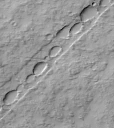
PIA01686: Chain of Pits on Pavonis Mons
 Target Name:  Mars
 Is a satellite of:  Sol (our sun)
 Mission:  Mars Global Surveyor (MGS)
 Spacecraft:  Mars Global Surveyor Orbiter
 Instrument:  Mars Orbiter Camera (MOC)
 Product Size:  659 x 740 pixels (w x h)
 Produced By:  Malin Space Science Systems
 Producer ID:  MOC2-99 P50291 MRPS94522
 Addition Date:  2000-06-17
 Primary Data Set:  MGS EDRs
 Full-Res TIFF:  PIA01686.tif (344.8 kB)
 Full-Res JPEG:  PIA01686.jpg (52.37 kB)

Click on the image above to download a moderately sized image in JPEG format (possibly reduced in size from original)

Original Caption Released with Image:

Pavonis Mons is the middle of the three large Tharsis Montes volcanoes in the martian western hemisphere. Located on the equator at about 113°W longitude, Pavonis Mons stands as much as 7 kilometers (4 miles) above the surrounding plain. The Mars Global Surveyor (MGS) Mars Orbiter Camera (MOC) recently spied the above chain of elliptical pits on the lower east flank of Pavonis Mons. The picture covers an area 3 kilometers (1.9 miles) wide by 3.4 kilometers (2.1 miles) in length. The pits are aligned down the center of a 485 meters-(530 yards)-wide, shallow trough. The straight trough and the pits were both formed by collapse associated with faulting. The scarp on each side of the trough is a fault line--troughs of this type are known to geologists as graben. Such features are typically formed when the ground is being moved apart by tectonic forces, or when the ground is uplifted by molten rock injected into the near sub-surface from deeper underground. Both processes may be contributing to the features seen on Pavonis Mons. The pits follow the trend of these faults, and indicate the locus of collapse. Illumination is from the upper left in this image.

Malin Space Science Systems and the California Institute of Technology built the MOC using spare hardware from the Mars Observer mission. MSSS operates the camera from its facilities in San Diego, CA. The Jet Propulsion Laboratory's Mars Surveyor Operations Project operates the Mars Global Surveyor spacecraft with its industrial partner, Lockheed Martin Astronautics, from facilities in Pasadena, CA and Denver, CO.

Image Credit:
NASA/JPL/MSSS

Image Addition Date:
2000-06-17