PDS logoPlanetary Data System
PDS Information
Find a Node - Use these links to navigate to any of the 8 publicly accessible PDS Nodes.

This bar indicates that you are within the PDS enterprise which includes 6 science discipline nodes and 2 support nodes which are overseen by the Project Management Office at NASA's Goddard Space Flight Center (GSFC). Each node is led by an expert in the subject discipline, supported by an advisory group of other practitioners of that discipline, and subject to selection and approval under a regular NASA Research Announcement.
Click here to return to the Photojournal Home Page Click here to view a list of Photojournal Image Galleries Photojournal_inner_header
Latest Images  |  Spacecraft & Technology  |  Animations  |  Space Images App  |  Feedback  |  Photojournal Search  

PIA01680: Boulder Tracks on Schiaparelli Basin South Wall
 Target Name:  Mars
 Is a satellite of:  Sol (our sun)
 Mission:  Mars Global Surveyor (MGS)
 Spacecraft:  Mars Global Surveyor Orbiter
 Instrument:  Mars Orbiter Camera (MOC)
 Product Size:  1323 x 1975 pixels (w x h)
 Produced By:  Malin Space Science Systems
 Producer ID:  MOC2-93 P50288 MRPS94515
 Addition Date:  2000-09-16
 Primary Data Set:  MGS EDRs
 Full-Res TIFF:  PIA01680.tif (1.978 MB)
 Full-Res JPEG:  PIA01680.jpg (321.9 kB)

Click on the image above to download a moderately sized image in JPEG format (possibly reduced in size from original)

Original Caption Released with Image:

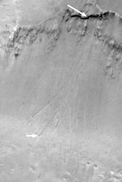
The above Mars Orbiter Camera (MOC) image shows a portion of the slope just inside the south rim of the approximately 400 kilometer-(250 mile)-wide Schiaparelli Basin near the martian equator. The large white arrow points to a steep cliff exposure of dark-toned rock. The small white arrow points to one of several ~18 meter (59 feet) diameter boulders that apparently broke off the steep, dark cliff and rolled down the slope to the basin floor. Each boulder left behind a trail on the relatively soft, dusty slope. In addition, some of the boulders exhibit a bright wind streak pointing toward the lower left/center, indicating that these boulders have been sitting there long enough to influence local wind distribution of sediment.

Before the Mars Global Surveyor (MGS) mission, boulder tracks such as these had never been seen on Mars before, but in the 1960s and 1970s several examples on the Moon and Earth were documented. The picture shown here covers an area approximately 2.8 kilometers (1.7 miles) by 4.4 kilometers (2.7 miles). Illumination is from the lower left. The picture was acquired in January 1998 during the MGS Aerobrake-1 Orbits imaging campaign, and was presented at the 30th Lunar and Planetary Science Conference in Houston, Texas, March 1999.

Malin Space Science Systems and the California Institute of Technology built the MOC using spare hardware from the Mars Observer mission. MSSS operates the camera from its facilities in San Diego, CA. The Jet Propulsion Laboratory's Mars Surveyor Operations Project operates the Mars Global Surveyor spacecraft with its industrial partner, Lockheed Martin Astronautics, from facilities in Pasadena, CA and Denver, CO.

Image Credit:
NASA/JPL/MSSS

Image Addition Date:
2000-09-16