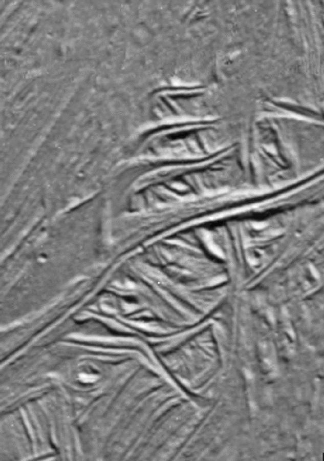
These cracks and ridges in the south polar region of Jupiter's moon Europa have been rotated into sigmoidal or "S" shapes by the motion of Astypalaea Linea, a strike-slip fault in the moon's icy surface. These cracks and ridges are located within Cyclades Macula, a region of the fault which has been pulled apart and created openings through which warmer, softer ice from below Europa's brittle ice shell surface, or frozen water from a possible subsurface ocean, could reach the surface. This upwelling of material formed large areas of new ice within the boundaries of the original fault. North is to the top of the picture. The once active fault structure is a barely visible line (right of center) that trends approximately north to south in this image.
An earlier northwest to southeast trending generation of rotated cracks underlies the more recent set. Such rotated structure is typical of a process known as "simple shear," and characterizes many large strike-slip faults on Earth. In this case, however, simple shear structures seem limited to the interior of the Cyclades Macula pull apart region and do not appear to border the elongate trunk of the fault, Astypalaea Linea. Comparisons between these structures related to faults on Europa and those on Earth may generate ideas useful in the study of terrestrial faulting.
The sun illuminates the surface from the top. The image, centered at 63 degrees south latitude and 191 degrees west longitude, covers an area approximately 15 by 10 kilometers (9 by 6 miles). The resolution is 40 meters (131 feet) per picture element. The images were taken on September 26, 1998 at a range of less than 4200 kilometers (2600 miles) by the Solid State Imaging (SSI) system on NASA's Galileo spacecraft.
The Jet Propulsion Laboratory, Pasadena, CA manages the Galileo mission for NASA's Office of Space Science, Washington, DC.
This image and other images and data received from Galileo are posted on the World Wide Web, on the Galileo mission home page at URLhttp://solarsystem.nasa.gov/galileo/. Background information and educational context for the images can be found at URLhttp://www.jpl.nasa.gov/galileo/sepo.


