PDS logoPlanetary Data System
PDS Information
Find a Node - Use these links to navigate to any of the 8 publicly accessible PDS Nodes.

This bar indicates that you are within the PDS enterprise which includes 6 science discipline nodes and 2 support nodes which are overseen by the Project Management Office at NASA's Goddard Space Flight Center (GSFC). Each node is led by an expert in the subject discipline, supported by an advisory group of other practitioners of that discipline, and subject to selection and approval under a regular NASA Research Announcement.
Click here to return to the Photojournal Home Page Click here to view a list of Photojournal Image Galleries Photojournal_inner_header
Latest Images  |  Spacecraft & Technology  |  Animations  |  Space Images App  |  Feedback  |  Photojournal Search  

PIA01612: A Tumultuous Past for Ganymede's Dark Terrain
 Target Name:  Ganymede
 Is a satellite of:  Jupiter
 Mission:  Galileo
 Spacecraft:  Galileo Orbiter
 Instrument:  Solid-State Imaging 
 Product Size:  615 x 519 pixels (w x h)
 Produced By:  Brown University
 Producer ID:  P50034 MRPS89762
 Addition Date:  1998-07-15
 Primary Data Set:  Galileo EDRs
 Full-Res TIFF:  PIA01612.tif (293 kB)
 Full-Res JPEG:  PIA01612.jpg (99.24 kB)

Click on the image above to download a moderately sized image in JPEG format (possibly reduced in size from original)

Original Caption Released with Image:

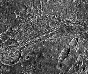
Dark terrain of Nicholson Regio on Jupiter's moon, Ganymede. On the left is a crater that has been torn apart by tectonic forces. A lane of ridges and grooves (probably extensional fault blocks) cuts through the crater and distorts its originally circular shape. Though such deformation is more typical of Ganymede's bright grooved terrain, this image demonstrates that extreme tectonic disruption has occurred in the satellite's dark terrain also. The pair of oblong craters on the right was formed by the impact of a gravitationally bound pair of asteroids or a split comet. The oblong shapes of the craters suggest that the impactors struck the surface at a shallow angle. Toward the top left, an old crater has been partially buried by dark ejecta tossed from another impact about 50 kilometers to the north of this image.

North is to the top of the picture and the sun illuminates the surface from the right. The image, centered at 14 degrees south latitude and 352 degrees longitude, covers an area approximately 111 by 93 kilometers. The resolution is 180 meters per picture element. The image was taken on April 5, 1997 at 6 hours, 31 minutes, 44 seconds Universal Time at a range of 17,840 kilometers by the Solid State Imaging (SSI) system on NASA's Galileo spacecraft.

The Jet Propulsion Laboratory, Pasadena, CA manages the Galileo mission for NASA's Office of Space Science, Washington, DC.

This image and other images and data received from Galileo are posted on the World Wide Web, on the Galileo mission home page at URL http://solarsystem.nasa.gov/galileo/. Background information and educational context for the images can be found at http://www.jpl.nasa.gov/galileo/sepo.

Image Credit:
NASA/JPL/Brown University

Image Addition Date:
1998-07-15