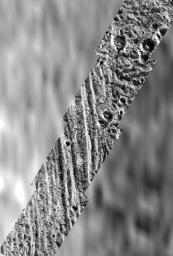
During Galileo's second orbit, a series of images were obtained within the northern polar cap of Jupiter's moon, Ganymede, across a north-south trending boundary between the grooved terrain of Philae Sulcus and the dark terrain of Galileo Regio. The blurry appearing background of this scene is the best Voyager image of the area, at a resolution of about 1.4 kilometers per picture element. The Voyager data shows that the grooved terrain of Philae Sulcus to the west (left) is bright, and the older terrain of Galileo Regio to the east (right) is dark; however, this brightness difference is not at all apparent in the high resolution Galileo images. Instead, bright and dark patches occur in both Philae Sulcus and in Galileo Regio. The bright patches occur mostly on the north and east facing slopes of craters and ridges, which are expected to be colder, and therefore to collect frost in this high latitude region. The principal way that Ganymede's terrain types can be distinguished in the high resolution Galileo images is by their texture: the "bright" grooved terrain shows north-south trending ridges and grooves, and the ancient "dark" terrain shows a rolling appearance and is more heavily cratered.
North is to the top of the picture and the sun illuminates the surface from the lower right. The image, centered at 63 degrees latitude and 168 degrees longitude, covers an area approximately 94 by 64 kilometers. The finest details that can discerned in this picture are about 92 meters across. The images were taken on September 6, 1996 beginning at 18 hours, 52 minutes, 46 seconds Universal Time at a range of 2266 kilometers by the Solid State Imaging (SSI) system on NASA's Galileo spacecraft.
The Jet Propulsion Laboratory, Pasadena, CA manages the Galileo mission for NASA's Office of Space Science, Washington, DC.
This image and other images and data received from Galileo are posted on the World Wide Web, on the Galileo mission home page at URL http:// galileo.jpl.nasa.gov. Background information and educational context for the images can be found at http://www.jpl.nasa.gov/galileo/sepo.

 Planetary Data System


