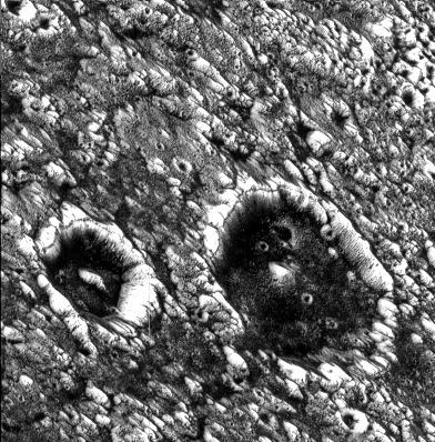
View of two impact craters that are superimposed on Memphis Facula, a large bright circular feature in the otherwise generally dark terrain in Galileo Regio on Jupiter's moon, Ganymede. These are thought to be impact craters because they share many of the features of such structures on other planets, including steep walls, flat floors, and central mountain peaks. Bright icy material is exposed on the walls, rims and peaks of these features and darker material can be seen covering the floors and streaming down the inner walls of the craters. The dark material may have been concentrated on the crater floors during the impact events. A dark line near the crater rim may be exposures of layered bedrock which has been uplifted. These craters have been degraded to the degree that their ejecta and surrounding secondary crater fields are no longer visible. The crater on the left (Chrysor) is about 6 kilometers (km) in diameter and the larger one on the right (Aleyn) is about 12 km wide. Smaller craters are seen as bright circles on the crater floors and in the surrounding areas. The density of these superposed impact features allows scientists to estimate the age of the surface and the age of the craters, thought to be many hundreds of millions of years old. Memphis Facula, a large 350 km diameter bright feature on which the craters are situated, appears to have formed from the excavation of bright water ice material during an ancient, large impact event.
North is to the top left of the picture and the sun illuminates the surface from the bottom. The image, centered at 15 degrees latitude and 134 degrees longitude, covers an area approximately 23 by 23 kilometers. The resolution is 59 meters per picture element. The image was taken on June 27, 1996 at 6 hours, 21 minutes, 19 seconds Universal Time at a range of 2849 kilometers by the Solid State Imaging (SSI) system on NASA's Galileo spacecraft.
The Jet Propulsion Laboratory, Pasadena, CA manages the Galileo mission for NASA's Office of Space Science, Washington, DC.
This image and other images and data received from Galileo are posted on the World Wide Web, on the Galileo mission home page at URL http://www.jpl.nasa.gov/galileo/sepo.