The Mars Global Surveyor (MGS) Mars Orbiter Camera (MOC) was designed--in part--to test the variety of hypotheses about the history of Mars that have been proposed since the Mariner and Viking missions of the 1960s and 1970s.
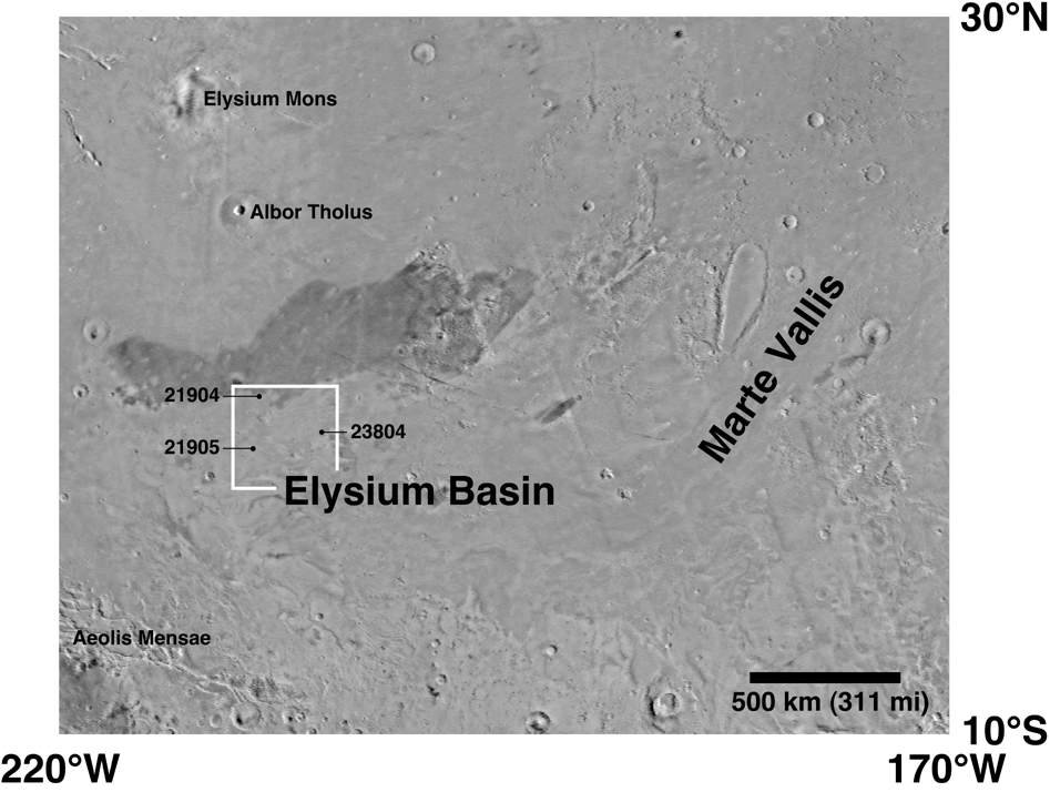
In April 1998, one of the efforts undertaken by the MOC science team was to test two competing ideas about the history of the Elysium Basin--a huge depression that stretches about 3,000 kilometers (1,865 miles) east-to-west in the region south of the Elysium volcanic rise.
There were two competing ideas about the Elysium Basin. One hypothesis held that the depression was once the site of a vast lake approximately 1,500 meters (4,900 feet) deep. Because the floor of Elysium Basin has very few small, fresh impact craters, it was proposed that this lake dried up relatively recently in martian history--that is, the lake would have been younger than most of the volcanoes, craters, and even the Ares Vallis flood channel in which is located the Mars Pathfinder landing site. At some point, the lake in Elysium Basin was thought to have reached such a depth that it began to spill over arise on its east end. The water spilling out the east end of Elysium Basin was thought to have created Marte Vallis--a channel containing streamlined islands that stretches for hundreds of kilometers (miles) to the northeast. The lake bed and channel, it was proposed, might make good places to land future rovers that could travel around and collect samples that might contain evidence of past martian life.
The other hypothesis held that the Elysium Basin floor was covered with flows that were emplaced as extremely fluid lava (molten rock). It was suggested that a lake of water could have been in the basin long, long ago, but that the most recent geologic events had erupted huge volumes of very fluid lava across the basin floor. Some of this lava was proposed to have even poured out of the basin and travelled down Marte Vallis. In this hypothesis, it was assumed that Marte Vallis--named for the Spanish word for "Mars"--was first carved by water, and then was a conduit for lava from volcanic eruptions. The lavas were proposed to have been very fluid--behaving almost limewater. Such fluid lavas are known on Earth to result from molten rock that has a low concentration of silica, a high temperature, and/or a high eruption rate.
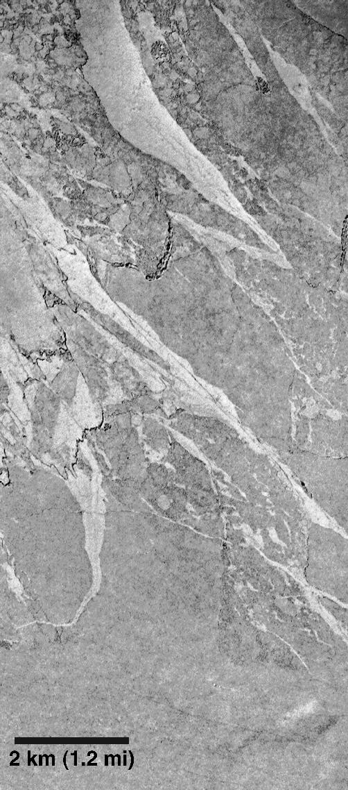
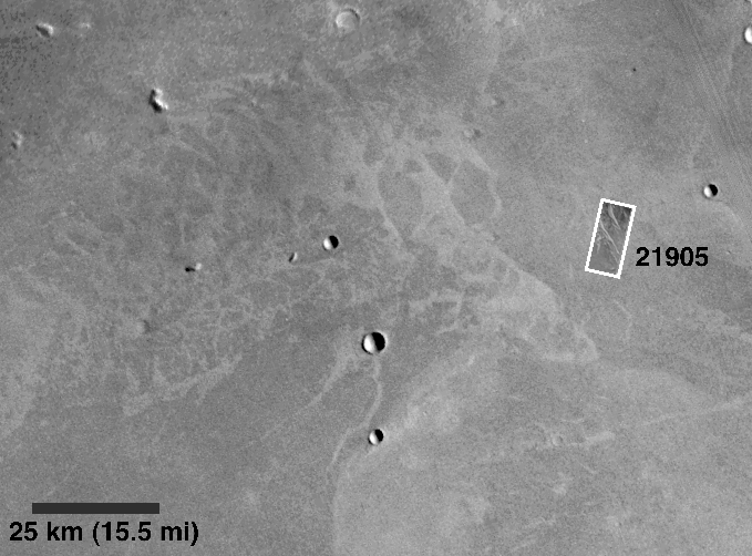
This MOC image, and MOC images 21904 and 23804, of the floor of Elysium Basin taken in April 1998 revealed that the basin floor is covered with lava, not lake sediment. In other words, MOC has found that the Elysium Basin might not be a good place to look for evidence of martian life that might have existed in a lake.
However, the lava textures that MOC found are striking and indicate something very important about the geologic history of Mars. The surface texture of this lava includes giant plates that appear to have been broken up and floated on the surface of a fluid. In this case, the fluid was molten lava. The implication is that the Elysium Basin was once the site of giant, ponded lava flows that were many hundreds of kilometers (miles) across.
With the MOC images in hand, it is now quite easy to understand the older, lower-resolution Viking images ( Elysium Basin and Marte Vallis region,Viking 1 base map from 631st orbit,Viking 1 mosaic of local context). These Viking images showed a surface of dark plates with intervening bright surfaces. But they did not make sense--some thought they could somehow be volcanic, others thought they might be related to differences in the way that wind had eroded a dried lakebed. Now it can be seen that there are many dark plates that once floated on molten lava. When the lava was erupted, the upper surface crusted and cooled. The textures in these lavas indicate that they flowed and became cracked. Some cracks widened, and portions of the surface crust became rafts of solid rock--a few many kilometers (miles) across--that moved in the direction that the lava underneath was flowing. Other Viking and MGS images have shown similar platey lava textures in Marte Vallis, suggesting the possibility that some of the lava spilled into this valley and flowed thousands of kilometers (hundreds of miles) to the northeast.
The sparse occurrence of younger impact craters on the platey lava surfaces suggests that the eruptions happened relatively recently in Mars history. These eruptions would be much younger than the youngest of the large martian volcanoes like Ascraeus Mons and Olympus Mons in the Tharsis region; but they would still have occurred many, many millions of years ago (i.e., the pictures are not evidence that Mars is volcanically active today).
The MOC science team is continuing to study the images of Marte Vallis and Elysium Basin. Similar lava textures have been seen elsewhere on the planet, and are leading to some interesting revisions of our understanding of the volcanic and geologic history of the red planet. It should be noted that the observation of a volcanic surface in Elysium basin does not rule out the possibility that the depression was also once the site of a water lake, nor is it clear whether Marte Vallis is the result of volcanism alone, or volcanism that occurred some time after water had been present to carve the channel system.
The results of the initial study of the Elysium Basin are given in a paper entitled "Mars Global Surveyor Camera Tests the Elysium Basin Controversy: It's Lava, Not Lake Sediments," by Alfred S. McEwen, K. S. Edgett, M. C. Malin, L. Keszthelyi, and P. Lanagan, presented at the Geological Society of America Annual Meeting on October 29, 1998.
Malin Space Science Systems and the California Institute of Technology built the MOC using spare hardware from the Mars Observer mission. MSSS operates the camera from its facilities in San Diego, CA. The Jet Propulsion Laboratory's Mars Surveyor Operations Project operates the Mars Global Surveyor spacecraft with its industrial partner, Lockheed Martin Astronautics, from facilities in Pasadena, CA and Denver, CO.
