On Earth, geologists use layers of rock to "read" the history of our planet. Where rocks were initially formed as layers of sediment, the historic record of Earth is deciphered by knowing that older layers are found beneath the younger layers. Scientists investigating changes in Earth's climate over the past few million years also use this principle to examine cores of ice from Greenland and Antarctica. Layered rock and layered polar deposits on Mars may also preserve a comparable record of that planet's geologic and environmental history.
The martian north and south polar regions are covered by large areas of layered deposits. Since their discovery in the early 1970's, these polar layered deposits have been cited as the best evidence that the martian climate experiences cyclic changes over time. It was proposed that detailed investigation of the polar layers (e.g., by landers and/or human beings) would reveal a climate record of Mars in much the same way that ice cores from Antarctica are used to study past climates on Earth. On January 3, 1999, NASA's Mars Polar Lander and Deep Space 2 Penetrators will launch on a journey to study the upper layers of these deposits in the martian southern hemisphere.
Meanwhile, investigation of the north polar layered deposits has advanced significantly this year with the acquisition of MGS data. The Mars Orbiter Laser Altimeter acquired new topographic profiles over the north polar deposits in June and early July, 1998, and dozens of new high resolution images were taken by the Mars Global Surveyor (MGS) Mars Orbiter Camera (MOC) from mid-July to mid-September, 1998. When it was proposed to NASA in 1985, one of the original objectives of MOC was to determine whether the polar layered deposits--then thought to consist of 10 to 100 layers each between 10 and 100 meters (33 to 330 feet) thick--have more and thinner layers in them. The layers were proposed to have formed by slow accumulation of dust and ice--perhaps only 100 micrometers (0.004 inches) per year. A layer 10 meters (33 feet) thick would take 100,000 years to accumulate, roughly equal to the timescale of climate changes predicted by computer models.
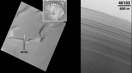
The image shown here (right image) was taken at 11:52 p.m. PDT on July 30, 1998, near the start of the 461st orbit of Mars Global Surveyor. The picture shows a slope along the edge of the permanent north polar cap of Mars that has dozens of layers exposed in it. The image shows many more layers than were visible to the Viking Orbiters in the 1970s (left images). The layers appear to have different thicknesses (some thinner than 10 meters (33 feet)) and different physical expressions. Some of the layers form steeper slopes than others, suggesting that they are more resistant to erosion. The more resistant layers might indicate that a cement (possibly ice) is present, making those layers stronger. All of the layers appear to have a rough texture that might be the result of erosion and/or redistribution of sediment and polar ice on the slope surface.
The presence of many more layers than were seen by Viking is an important and encouraging clue that suggests that future investigation of polar layered deposits by landers and, perhaps some day, by human explorers, will eventually lead to a better understanding of the of the polar regions and the climate history recorded there. Our view of these deposits will be much improved--starting in late March 1999--when the Mapping Phase of the MGS mission begins, and MOC will be able to obtain images with resolutions of 1.5 meters (5 feet) per pixel.
[The Viking Images (left)]: Regional and local context of MOC image 46103. The small figure in the upper right corner is a map of the north polar region, centered on the pole with 0° longitude located in the lower middle of the frame. A small black box within the polar map indicates the location of the Viking Orbiter 2 image used here for local context. The Viking image, 560b60, was taken in March 1978, toward the end of Northern Spring. The thin strip superposed on the Viking image is MOC image 46103, reduced in size to mark its placement relative to the Viking context image. The black box on the MOC image shows the location of the subframe highlighted here (right image). Illumination is from the left in the Viking image. The 10 kilometer scale bar also represents approximately 6.2 miles.
Malin Space Science Systems and the California Institute of Technology built the MOC using spare hardware from the Mars Observer mission. MSSS operates the camera from its facilities in San Diego, CA. The Jet Propulsion Laboratory's Mars Surveyor Operations Project operates the Mars Global Surveyor spacecraft with its industrial partner, Lockheed Martin Astronautics, from facilities in Pasadena, CA and Denver, CO.

 Planetary Data System


