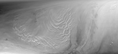
Mars Global Surveyor's Mars Orbiter Camera obtained its last SPO-2 images of Mars on September 12, 1998. SPO-2, or "Science Phasing Orbit-2," took place between early June and mid-September 1998. Shown above are MOC wide angle (red and blue band) images of the martian north polar region obtained around 3:15 a.m. PDT on September 12, 1998. This image, MOC image 55001, was one of the last pictures taken of the planet until the camera resumes its work in late-March 1999.
The north polar layered deposits, a terrain believed composed of ice and dust deposited over millions of years, dominates this view. The swirled pattern in the images above are channels eroded into this deposit. The pattern is accentuated by the illumination and seasonal frost differences that arise on sun-facing slopes during the summer. The permanent portion of the north polar cap covers most of the region with a layer of ice of unknown thickness.
At the time this picture was obtained, the martian northern hemisphere was in the midst of the early Spring season. The margin of the seasonal carbon dioxide frost cap was at about 67° N, so the ground throughout this image is covered by frost. The frost appears pink rather than white; this may result from textural changes in the frost as it sublimes or because the frost is contaminated by a small amount of reddish martian dust. Please note that these pictures have not been "calibrated" and so the colors are not necessarily accurately portrayed.
In addition to the north polar cap, the pictures also show some clouds. Some of the clouds on the right side of the images are long, linear features that cast similar long, dark shadows on the ground beneath them.
When the MOC resumes imaging of Mars in March 1999, summer will have arrived in the north polar regions and the area surrounding the permanent polar cap will appear much darker than it does here. The dark features surrounding the cap are sand dunes, and these are expected to darken over the next several months as seasonal ice sublimes and is removed from the surface.
Malin Space Science Systems and the California Institute of Technology built the MOC using spare hardware from the Mars Observer mission. MSSS operates the camera from its facilities in San Diego, CA. The Jet Propulsion Laboratory's Mars Surveyor Operations Project operates the Mars Global Surveyor spacecraft with its industrial partner, Lockheed Martin Astronautics, from facilities in Pasadena, CA and Denver, CO.
 Planetary Data System


