On July 20, 1969, the first human beings landed on the Moon. On July 20, 1976, the first robotic lander touched down on Mars. This July 20th -- 29 years after Apollo 11 and 22 years since the Viking 1 Mars landing -- we take a look forward toward one possible future exploration site on the red planet.
One of the advantages of the Mars Global Surveyor Mars Orbiter Camera (MOC) over its predecessors on the Viking and Mariner spacecraft is resolution. The ability to see -- resolve-- fine details on the martian surface is key to planning future landing sites for robotic and, perhaps, human explorers that may one day visit the planet.
At present, NASA is studying potential landing sites for the Mars Surveyor landers, rovers, and sample return vehicles that are scheduled to be launched in 2001, 2003, and 2005. Among the types of sites being considered for these early 21st Century landings are those with "exobiologic potential" -- that is, locations on Mars that are in some way related to the past presence of water.
For more than a decade, two of the prime candidates suggested by various Mars research scientists are Gusev Crater and Ma'adim Vallis. Located in the martian southern cratered highlands at 14.7° S, 184.5° W, Gusev Crater is a large, ancient, meteor impact basin that -- after it formed -- was breached by Ma'adim Vallis.
Viking Orbiter observations provided some evidence to suggest that a fluid -- most likely, water -- once flowed through Ma'adim Vallis and into Gusev Crater. Some scientists have suggested that there were many episodes of flow into Gusev Crater (as well as flow out of Gusev through its topographically-lower northwestern rim). Some have also indicated that there were times when Ma'adim Vallis, also, was full of water such that it formed a long, narrow lake.
The possibility that water flowed into Gusev Crater and formed a lake has led to the suggestion that the materials seen on the floor of this crater -- smooth-surfaced deposits, buried craters, and huge mesas near the mouth of Ma'adim Vallis -- are composed of sediment that eroded out of the highlands to the south of Gusev Crater. In 1995, the Exobiology Program Office at NASA Headquarters produced a report, An Exobiological Strategy for Mars Exploration (NASA SP-530), that included Gusev Crater as a possible priority site for future Mars exploration because it might once have been a lake.
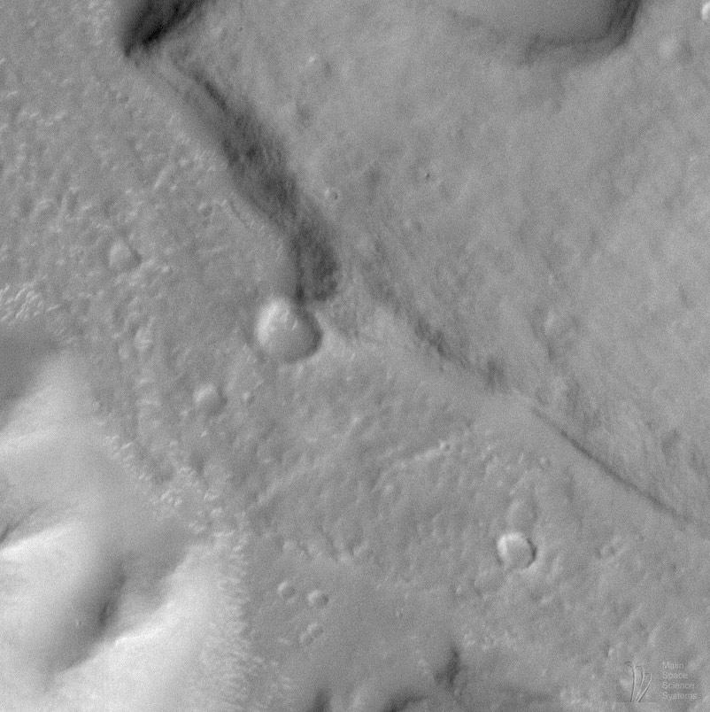
At 12:17 a.m. (PDT) on April 24, 1998 -- during Mars Global Surveyor's 259th orbit -- MOC obtained the high resolution image of Gusev Crater and Ma'adim Vallis shown above, in part to test some of the proposed hypotheses. The raw image has a scale of 7.3 meters (24 feet) per pixel. At this scale, there are no obvious shorelines that would indicate the past presence of a lake in either Ma'adim Vallis or Gusev Crater. There are several alternative explanations for this absence, including:
- It is possible that any lake in Gusev occurred so long ago that erosion by wind and hillslope processes have long since removed such features.
- It is possible that 7.3 meters per pixel is insufficient to identify key diagnostic lake features.
- It is possible that a lake once existed, but that shore- and near-shore processes as they occur in terrestrial lake environments did not occur on Mars.
- It is possible no lake ever existed.
When Mars Global Surveyor achieves its Mapping Orbit in March 1999, MOC will have the ability to obtain pictures with resolutions around 1.5 meters (5 feet) per pixel. Sometime during the mapping mission, it may be possible to image Gusev Crater again to look for potential lake features and possible future landing sites.Malin Space Science Systems and the California Institute of Technology built the MOC using spare hardware from the Mars Observer mission. MSSS operates the camera from its facilities in San Diego, CA. The Jet Propulsion Laboratory's Mars Surveyor Operations Project operates the Mars Global Surveyor spacecraft with its industrial partner, Lockheed Martin Astronautics, from facilities in Pasadena, CA and Denver, CO.obal Surveyor spacecraft with its industrial partner, Lockheed Martin Astronautics, from facilities in Pasadena, CA and Denver, CO.
 Planetary Data System


