PDS logoPlanetary Data System
PDS Information
Find a Node - Use these links to navigate to any of the 8 publicly accessible PDS Nodes.

This bar indicates that you are within the PDS enterprise which includes 6 science discipline nodes and 2 support nodes which are overseen by the Project Management Office at NASA's Goddard Space Flight Center (GSFC). Each node is led by an expert in the subject discipline, supported by an advisory group of other practitioners of that discipline, and subject to selection and approval under a regular NASA Research Announcement.
Click here to return to the Photojournal Home Page Click here to view a list of Photojournal Image Galleries Photojournal_inner_header
Latest Images  |  Spacecraft & Technology  |  Animations  |  Space Images App  |  Feedback  |  Photojournal Search  

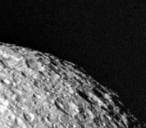
PIA01386: High Resolution View of Tethys
 Target Name:  Tethys
 Is a satellite of:  Saturn
 Mission:  Voyager
 Spacecraft:  Voyager 2
 Instrument:  VG ISS - Narrow Angle
 Product Size:  260 x 228 pixels (w x h)
 Produced By:  JPL
 Producer ID:  P23950
 Addition Date:  1999-01-05
 Primary Data Set:  Voyager EDRs
 Full-Res TIFF:  PIA01386.tif (51.78 kB)
 Full-Res JPEG:  PIA01386.jpg (9.486 kB)

Click on the image above to download a moderately sized image in JPEG format (possibly reduced in size from original)

Original Caption Released with Image:

This highest-resolution view of Tethys was obtained Aug. 26 when Voyager 2 was 120,000 kilometers (74,500 miles) from this satellite of Saturn. This image was taken 1 1/2 hours after the spacecraft passed through the planet's ring plane. The smallest features visible here are about 2.2 km. (1.4 mi.) across. The heavily cratered terrain implies a very old surface that has changed little since shortly after the solar system formed. Tethys is a bright object made largely of ice; it has a diameter of 1,050 km. (650 mi.). The Voyager project is managed for NASA by the Jet Propulsion Laboratory, Pasadena, Calif.

Image Credit:
NASA/JPL

Image Addition Date:
1999-01-05