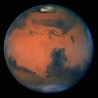
The sharpest view of Mars ever taken from Earth was obtained by the recently refurbished NASA Hubble Space Telescope (HST). This stunning portrait was taken with the HST Wide Field Planetary Camera-2 (WFPC2) on March 10, 1997, just before Mars opposition, when the red planet made one of its closest passes to the Earth (about 60 million miles or 100 million km).
At this distance, a single picture element (pixel) in WFPC2's Planetary Camera spans 13 miles (22 km) on the Martian surface.
The Martian north pole is at the top (near the center of the bright polar cap) and East is to the right. The center of the disk is at about 23 degrees north latitude, and the central longitude is near 305 degrees.
This view of Mars was taken on the last day of Martian spring in the northern hemisphere (just before summer solstice). It clearly shows familiar bright and dark markings known to astronomers for more than a century. The annual north polar carbon dioxide frost (dry ice) cap is rapidly sublimating (evaporating from solid to gas), revealing the much smaller permanent water ice cap, along with a few nearby detached regions of surface frost. The receding polar cap also reveals the dark, circular sea of sand dunes that surrounds the north pole (Olympia Planitia).
Other prominent features in this hemisphere include Syrtis Major Planitia, the large dark feature seen just below the center of the disk. The giant impact basin Hellas (near the bottom of the disk) is shrouded in bright water ice clouds. Water ice clouds also cover several great volcanos in the Elysium region near the eastern edge of the planet (right). A diffuse water ice haze covers much of the Martian equatorial region as well.
The WFPC2 was used to monitor dust storm activity to support the Mars Pathfinder and Mars Global Surveyor Orbiter Missions, which are currently en route to Mars. Airborne dust is most easily seen in WFPC2's red and near-infrared images. Hubble's "weather report" from these images in invaluable for Mars Pathfinder, which is scheduled for a July 4 landing. Fortunately, these images show no evidence for large-scale dust storm activity, which plagued a previous Mars mission in the early 1970s.
The WFPC2 was used to observe Mars in nine different colors spanning the ultraviolet to the near infrared. The specific colors were chosen to clearly discriminate between airborne dust, ice clouds, and prominent Martian surface features. This picture was created by combining images taken in blue (433 nm), green (554 nm), and red (763 nm) colored filters.
This image and other images and data received from the Hubble Space Telescope are posted on the World Wide Web on the Space Telescope Science Institute home page at URL http://oposite.stsci.edu/.
 Planetary Data System


