PDS logoPlanetary Data System
PDS Information
Find a Node - Use these links to navigate to any of the 8 publicly accessible PDS Nodes.

This bar indicates that you are within the PDS enterprise which includes 6 science discipline nodes and 2 support nodes which are overseen by the Project Management Office at NASA's Goddard Space Flight Center (GSFC). Each node is led by an expert in the subject discipline, supported by an advisory group of other practitioners of that discipline, and subject to selection and approval under a regular NASA Research Announcement.
Click here to return to the Photojournal Home Page Click here to view a list of Photojournal Image Galleries Photojournal_inner_header
Latest Images  |  Spacecraft & Technology  |  Animations  |  Space Images App  |  Feedback  |  Photojournal Search  

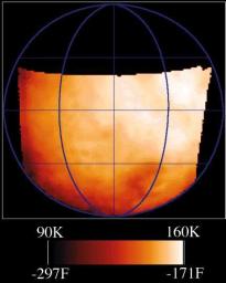
PIA01232: Temperature Map of Ganymede
 Target Name:  Ganymede
 Is a satellite of:  Jupiter
 Mission:  Galileo
 Spacecraft:  Galileo Orbiter
 Instrument:  Photopolarimeter-Radiometer 
 Product Size:  432 x 540 pixels (w x h)
 Produced By:  JPL
 Producer ID:  P49778 MRPS87788
 Addition Date:  1998-04-02
 Primary Data Set:  Galileo EDRs
 Full-Res TIFF:  PIA01232.tif (422.9 kB)
 Full-Res JPEG:  PIA01232.jpg (29.2 kB)

Click on the image above to download a moderately sized image in JPEG format (possibly reduced in size from original)

Original Caption Released with Image:

This map shows the temperatures for most of the surface of Ganymede made from data taken by the Photopolarimeter/Radiometer (PPR) instrument on June 26, 1996 as Galileo approached the sunlit side of the moon. The color bar shows the range of temperatures of this data, with the dark red being the coldest and white being the warmest. This is similar to the temperature forecast maps that you see on the evening news or in some newspapers. The difference between this map and one of Earth is that PPR measures the temperature of the surface (the ground), instead of air temperature. Ganymede is much colder than Earth, with these daytime temperatures ranging across the surface from 90 to 160 Kelvin (or -297 to -171 degrees Fahrenheit). Jupiter and its moons receive less than 1/30th the amount of sunlight that the Earth does, and Ganymede has essentially no atmosphere to trap heat. Ganymede's day is just over 7 Earth days long, the same time it takes to orbit Jupiter once.

To compare this temperature map to surface features of Ganymede, you can look at this Ganymede Image taken during the Ganymede 1 orbit. The PPR map covers almost the same area as the image but is rotated about 30 degrees to the west.

The image was taken with Galileo's PPR (Photopolarimeter-Radiometer) instrument on the spacecraft's seventh orbit around Jupiter, from a range of about 65,000 kilometers (40,389 miles). Surface temperatures derived from the strength of infrared radiation, as was done here, are called "brightness temperatures," and may be slightly in error.

JPL manages the Galileo mission for NASA's Office of Space Science, Washington, D.C.

This image and other images and data received from Galileo are posted on the World Wide Web, on the Galileo mission home page at URL http://galileo.jpl.nasa.gov.

Image Credit:
NASA/JPL

Image Addition Date:
1998-04-02