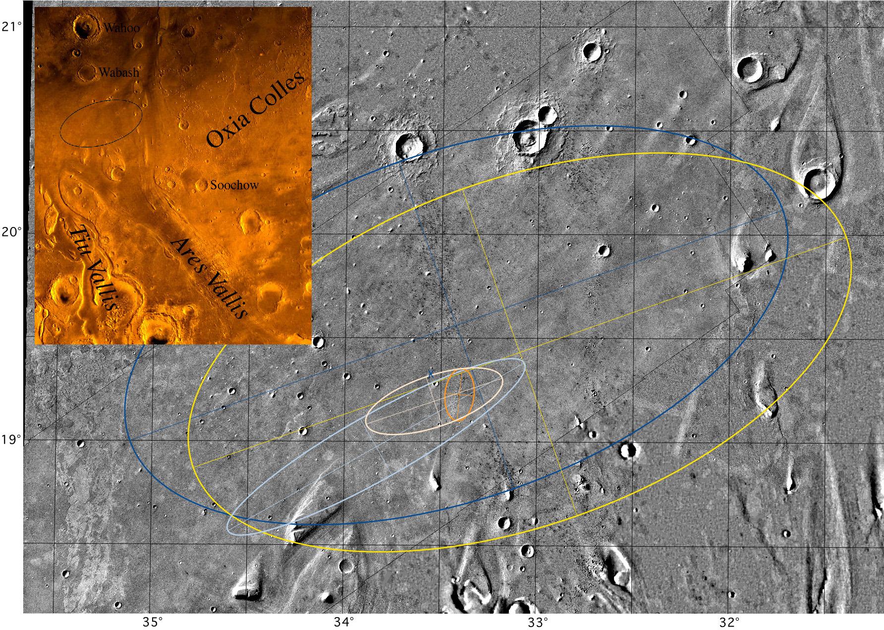
Mosaic of Ares Vallis showing different landing ellipses, with color inset of the Chryse Planitia region of Mars showing the outflow channels. The large blue ellipse (100 km by 200 km) to the northwest is an ellipse in the USGS cartographic reference frame designed to avoid streamlined hills to the south and east, craters to the north, and etched terrain to the west (this ellipse is shown in the color inset). The large yellow ellipse (100 km by 200 km) displaced toward the southeast (by 20 km in longitude and 8 km in latitude) is the navigation target ellipse in the revised local cartographic reference frame (which are the latitude and longitude shown in this figure). The elongate light blue ellipse (98 km by 19 km) is the navigation prediction as of late 3 July and early 4 July; it includes part of the streamlined island in the southwest. The gold ellipse (15 km by 8 km) is the prediction with tracking through atmospheric entry. The pink ellipse (41 km by 15 km), which encloses the smallest ellipse (and the location of the lander), is the navigation result with dispersions added for atmospheric entry and descent. The blue X is the location of the lander with respect to surface features identified in Viking orbiter images (located at 19.33 degrees N, 33.55 degrees W in the local reference frame). The location of the lander in inertial space (19.30 degrees N, 33.52 degrees W) from the two-way ranging and Doppler tracking of the lander is at the very northwest edge of the crater, just 2.2 km to the south-southeast of the X. If the location of the lander in inertial space is forced to coincide with its location with respect to surface features, then the resulting cartographic frame is actually 2 km to the south and 0.8 km to the east of the local network. Color mosaic is part of the Oxia Palus Quadrangle (MC 11) of Mars; black and white mosaic from Viking orbiter images of 38 m/pixel resolution; north is at the top.
NOTE: original caption as published in Science magazine.
Photojournal note: Sojourner spent 83 days of a planned seven-day mission exploring the Martian terrain, acquiring images, and taking chemical, atmospheric and other measurements. The final data transmission received from Pathfinder was at 10:23 UTC on September 27, 1997. Although mission managers tried to restore full communications during the following five months, the successful mission was terminated on March 10, 1998.
 Planetary Data System


