PDS logoPlanetary Data System
PDS Information
Find a Node - Use these links to navigate to any of the 8 publicly accessible PDS Nodes.

This bar indicates that you are within the PDS enterprise which includes 6 science discipline nodes and 2 support nodes which are overseen by the Project Management Office at NASA's Goddard Space Flight Center (GSFC). Each node is led by an expert in the subject discipline, supported by an advisory group of other practitioners of that discipline, and subject to selection and approval under a regular NASA Research Announcement.
Click here to return to the Photojournal Home Page Click here to view a list of Photojournal Image Galleries Photojournal_inner_header
Latest Images  |  Spacecraft & Technology  |  Animations  |  Space Images App  |  Feedback  |  Photojournal Search  

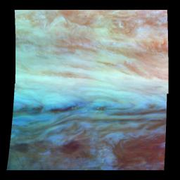
PIA01116: False Color Mosaic of Jupiter's Belt-Zone Boundary
 Target Name:  Jupiter
 Is a satellite of:  Sol (our sun)
 Mission:  Galileo
 Spacecraft:  Galileo Orbiter
 Instrument:  Solid-State Imaging 
 Product Size:  800 x 800 pixels (w x h)
 Produced By:  California Institute of Technology 
 Producer ID:  P49565 MRPS78866
 Addition Date:  1997-12-18
 Primary Data Set:  Galileo EDRs
 Full-Res TIFF:  PIA01116.tif (1.401 MB)
 Full-Res JPEG:  PIA01116.jpg (56.68 kB)

Click on the image above to download a moderately sized image in JPEG format (possibly reduced in size from original)

Original Caption Released with Image:

False-color mosaic of a belt-zone boundary near Jupiter's equator. The images that make up the four quadrants of this mosaic were taken within a few minutes of each other. Light at each of Galileo's three near-infrared wavelengths is displayed here mapped to the visible colors red, green, and blue. Light at 886 nanometers, strongly absorbed by atmospheric methane and scattered from clouds high in the atmosphere, is shown in red. Light at 732 nanometers, moderately absorbed by atmospheric methane, is shown in green. Light at 757 nanometers, scattered mostly from Jupiter's lower visible cloud deck, is shown in blue. The lower cloud deck appears bluish white, while the higher layer appears pinkish. The holes in the upper layer and their relationships to features in the lower cloud deck can be studied in the lower half of the mosaic. Galileo is the first spacecraft to image different layers in Jupiter's atmosphere.

North is at the top. The mosaic covers latitudes -13 to +3 degrees and is centered at longitude 282 degrees West. The smallest resolved features are tens of kilometers in size. These images were taken on November 5th, 1996, at a range of 1.2 million kilometers by the Solid State Imaging system aboard NASA's Galileo spacecraft.

The Jet Propulsion Laboratory, Pasadena, CA manages the mission for NASA's Office of Space Science, Washington, DC.

This image and other images and data received from Galileo are posted on the World Wide Web, on the Galileo mission home page at URL http://galileo.jpl.nasa.gov. Background information and educational context for the images can be found at http://www.jpl.nasa.gov/galileo/sepo.

Image Credit:
NASA/JPL-Caltech

Image Addition Date:
1997-12-18