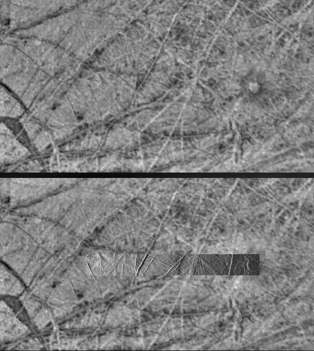
These images obtained by the Solid State Imaging (CCD) system aboard NASA's Galileo spacecraft show the same region of Europa under different lighting conditions. The upper image was obtained on June 28th, 1996 during Galileo's first orbit around Jupiter under "high-sun" conditions -- the equivalent of taking a picture from a high altitude at noon (with the sun directly overhead). Note that albedo (light/dark) features are emphasized. Compare this to the lower image containing a higher-resolution inset. This (inset) image was taken on November 6th, 1996 during the spacecraft's third orbit under "low-sun" illumination -- the equivalent of taking a picture from a high altitude at sunrise or sunset. Note that in this image the albedo features are not readily apparent. Instead, the topography of the terrain is emphasized. Planetary geologists use information from images acquired under a variety of lighting conditions to identify different types of structures and interpret how they formed. Note that the bright linear features in the upper image are seen to be ridges in the lower image. The circular feature on the right side of both images, Cilix, is approximately 25 kilometers (15 miles) across.
The area seen in the upper image is 312 kilometers (187 miles) by 570 kilometers (342 miles) across; the area covered by the inset is 36 kilometers (22 miles) by 315 kilometers (190 miles) across. Both of these images are centered near 2 South latitude, 185 West longitude. North is to the top of the frames.
The Jet Propulsion Laboratory, Pasadena, CA manages the mission for NASA's Office of Space Science, Washington, DC.
This image and other images and data received from Galileo are posted on the World Wide Web, on the Galileo mission home page at URL http://galileo.jpl.nasa.gov. Background information and educational context for the images can be found at http://www.jpl.nasa.gov/galileo/sepo.
 Planetary Data System


