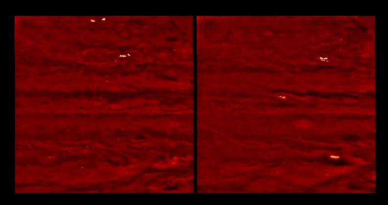
Jovian lightning and moonlit clouds. These two images, taken 75 minutes apart, show lightning storms on the night side of Jupiter along with clouds dimly lit by moonlight from Io, Jupiter's closest moon. The images were taken in visible light and are displayed in shades of red. The images used an exposure time of about one minute, and were taken when the spacecraft was on the opposite side of Jupiter from the Earth and Sun. Bright storms are present at two latitudes in the left image, and at three latitudes in the right image. Each storm was made visible by multiple lightning strikes during the exposure. Other Galileo images were deliberately scanned from east to west in order to separate individual flashes. The images show that Jovian and terrestrial lightning storms have similar flash rates, but that Jovian lightning strikes are a few orders of magnitude brighter in visible light.
The moonlight from Io allows the lightning storms to be correlated with visible cloud features. The latitude bands where the storms are seen seem to coincide with the "disturbed regions" in daylight images, where short-lived chaotic motions push clouds to high altitudes, much like thunderstorms on Earth. The storms in these images are roughly one to two thousand kilometers across, while individual flashes appear hundreds of kilometer across. The lightning probably originates from the deep water cloud layer and illuminates a large region of the visible ammonia cloud layer from 100 kilometers below it.
There are several small light and dark patches that are artifacts of data compression. North is at the top of the picture. The images span approximately 50 degrees in latitude and longitude. The lower edges of the images are aligned with the equator. The images were taken on October 5th and 6th, 1997 at a range of 6.6 million kilometers by the Solid State Imaging (SSI) system on NASA's Galileo spacecraft.
The Jet Propulsion Laboratory, Pasadena, CA manages the Galileo mission for NASA's Office of Space Science, Washington, DC. JPL is an operating division of California Institute of Technology (Caltech).
This image and other images and data received from Galileo are posted on the World Wide Web, on the Galileo mission home page at URL http://galileo.jpl.nasa.gov.
 Planetary Data System


