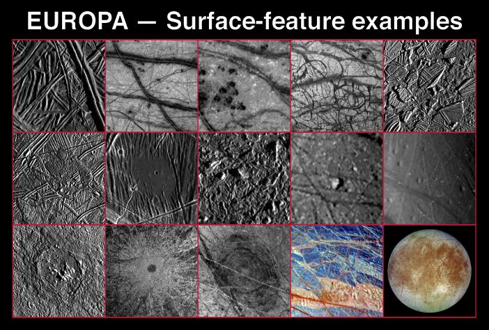
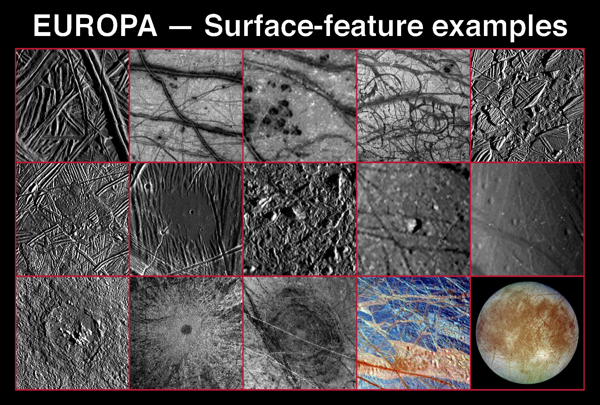
DESCRIPTIONS AND APPROXIMATE RESOLUTIONS| Ridges and Lineaments 27 meters/pixel | Triple Bands 1.6 kilometers/pixel | Dark Spots 1.6 kilometers/pixel | "Pull-apart" Terrain 1.6 kilometers/pixel | "Raft" Terrain 250 meters/pixel |
| Flows 225 meters/pixel | "Puddle" 27 meters/pixel | Mottled Terrain 35 meters/pixel | Knobs 1.6 kilometers/pixel | Pits 1.6 kilometers/pixel |
| Crater 300 meters/pixel | Crater Ejecta 1.4 kilometers/pixe | "Macula" 600 meters/pixel | IR-Bright/Dark Terrain 1.6 kilometers/pixel | Global View 7 kilometers/pixel |
These 15 frames show the great variety of surface features on Jupiter's icy moon, Europa, which have been revealed by the Galileo spacecraft Solid State Imaging (CCD) system during its first six orbits around Jupiter from June 1996 to February 1997. North is to the top of each of the images. The features seen on Europa's surface document both internal and external processes shaping the icy crust. Internal processes and the possible presence of liquid water beneath the ice are indicated by features such as "dark spots", lobe-shaped flow features, "puddles", "mottled terrain", knobs, pits, and the darker areas along ridges and triple bands.
Europa is subjected to constant tugging from the giant planet, Jupiter, as well as from its neighboring moons, Io and Ganymede. This causes "tidal" forces that affect Europa's interior and surface. Evidence for such forces includes ridges, fractures, wedge-shaped bands, and areas of "chaos." Some of these features result from alternate extension and compression buckling and pulling apart Europa's icy shell.
Impact craters document external effects on a planet's surface. Although present on Europa, impact craters are relatively scarce compared to the number seen on Ganymede, Callisto, and on the surfaces of most other "rocky" planets and moons in our solar system. This scarcity of craters suggests that the surface of Europa is very young. "Maculae" on Europa may be the scars from large impact events.
These images have resolutions from 27 meters (89 feet) to 7 kilometers (4.3 miles) per picture element (pixel) and were taken by Galileo at ranges of 2,500 kilometers (1,525 miles) to 677,000 kilometers (413,000 miles) from Europa.
Beginning with the upper left corner and moving left to right, top to bottom, the images show:
1. Ridges and lineaments crisscross the icy shell of Europa's surface. These are the most common landform on Europa and may represent either ejection of material from beneath its icy shell, or crumpling of the shell itself. Features as small as 54 meters (179 feet) across can be seen in this image, taken when Galileo was 2,550 kilometers (1,560 miles) from Europa.
2. Triple bands, seen by Voyager as linear features with a bright center and dark flanks, crisscross the surface of Europa. In high resolution Galileo images, these bands resolve into multiple ridges with diffuse darker deposits along the edges. Features as small as 3.2 kilometers (2 miles) across can be seen in this image, taken when Galileo was 155,000 kilometers (94,550 miles) from Europa.
3. Several "dark spots", areas of lower albedo (brightness) than the surrounding icy crust of Europa. These features, first identified in Voyager images, are seen to have diffuse outer margins and little topography. Features as small as 3.2 kilometers (2 miles) across can be seen in this image, taken when Galileo was 155,000 kilometers (94,550 miles) from Europa.
4. Wedge shaped bands of lower albedo than the surrounding areas. These areas appear to represent places where Europa's icy crust has been pulled apart and new material has filled in the area between the diverging ice sheets. Features as small as 3.2 kilometers (2 miles) across can be seen in this image, taken when Galileo was 155,000 kilometers (94,550 miles) from Europa.
5. An area known as "Conamara Chaos", characterized by polygonal sections of Europa's icy crust that broadly resemble icebergs. Individual ice RraftsS have been tilted, rotated and displaced from their original positions for distances of several kilometers. This terrain suggests that liquid water or ductile ice was present near the surface. Features as small as 500 meters (1,650 feet) across can be seen in this image, taken when Galileo was 17,936 kilometers (10,941 miles) from Europa.
6. Lobe shaped features that appear to be the icy equivalent of lava flows on Earth. Material has "erupted" through the icy shell and flowed over the surface of Europa for up to 30 kilometers (18 miles). Features as small as 450 meters (1,490 feet) across can be seen in this image, taken when Galileo was 17,684 kilometers (10,787 miles) from Europa.
7. A "puddle" of smooth material that appears to have buried parts of ridges. This feature is highly suggestive of liquid water or a water/ice slurry that locally flooded the European surface. The central crater is a coincidental feature produced by the subsequent impact of a meteor. Features as small as 54 meters (179 feet) across can be seen in this image, taken when Galileo was 2,491 kilometers (1,520 miles) from Europa.
8. A high resolution view of "mottled" terrain on Europa. This terrain, first discovered by Voyager was imaged at much higher resolution by Galileo. It is characterized by local darkening of the icy surface, in association with numerous small hills or "hummocks." The origin of this terrain remains enigmatic. Features as small as 70 meters (232 feet) across can be seen in this image, taken when Galileo was 3,344 kilometers (2,040 miles) from Europa.
9. Isolated hills or "knobs" on the surface of Europa. Although surface relief on Europa is typically very small (<100-200 meters or 110-220 yards), a steep sided knob known as Cilix is the most striking topographic feature on Europa, and is about 1.5 kilometers (1 mile) high. Features as small as 3.2 kilometers (2 miles) across can be seen in this image, taken when Galileo was 155,000 kilometers (94,550 miles) from Europa.
10. Closed depressions or "pits" on the surface of Europa. These features are typically less than 10 kilometers (6 miles) in longest dimension and have depths of less than 200 meters (660 feet). Features as small as 3.2 kilometers (2 miles) across can be seen in this image, taken when Galileo was 155,000 kilometers (94,550 miles) from Europa.
11. One of the few fresh craters on the surface of Europa. This crater, know as Pwyll, is 25 kilometers (15 miles) in diameter. The relative lack of impact craters on Europa, compared to Ganymede, Callisto and most other planetary surfaces in the solar system, suggests a relatively young age for the surface of Europa. Features as small as 600 meters (1,990 feet) across can be seen in this image, taken when Galileo was 11,644 kilometers (7,103 miles) from Europa.
12. Bright ejecta from the impact crater Pwyll. The ejecta and bright rays from Pwyll can be traced for over 1,000 kilometers (610 miles) across the surface of Europa. Features as small as 2.8 kilometers (1.7 miles) across can be seen in this image, taken when Galileo was 120,220 kilometers (73,330 miles) from Europa.
13. A large circular feature known as Tyre Macula, possibly a remnant of a large impact on EuropaUs icy surface. This feature is characterized by a set of concentric circular fractures more than 100 kilometers (61 miles) across, with little or no topography. Features as small as 1.2 kilometers (0.7 miles) across can be seen in this image, taken when Galileo was 29,300 kilometers (17,870 miles) from Europa.
14. "Color" differences in the icy surface of Europa newly discovered by Galileo. The color differences occur in the infrared (IR) portion of the electromagnetic spectrum, and represent either slight compositional differences or differences in the grain size of ice. IR bright terrain appears brownish white here, and IR dark terrain appears bluish in this false color image. Features as small as 3.2 kilometers (2 miles) across can be seen in this image, taken when Galileo was 155,000 kilometers (94,550 miles) from Europa.
15. A global view of Europa's trailing hemisphere. Visible in this view are mottled terrain, triple bands, crater Pwyll, a macula, and IR bright and dark plains. The minimum feature size visible in this image is 14 kilometers (8.6 miles). This image was taken when Galileo was 677,000 kilometers (413,000 miles) from Europa.
The Jet Propulsion Laboratory, Pasadena, CA manages the Galileo mission for NASA's Office of Space Science, Washington, DC. JPL is an operating division of California Institute of Technology (Caltech).
This image and other images and data received from Galileo are posted on the World Wide Web, on the Galileo mission home page at URL http://www.jpl.nasa.gov/galileo. Background information and educational context for the images can be found at URL http://www.jpl.nasa.gov/galileo/sepo