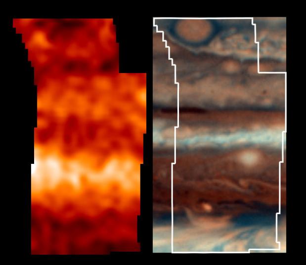
This is one of the highest resolution images ever recorded of Jupiter's temperature field. It was obtained by NASA's Galileo mission, with its Photopolarimeter-Radiometer (PPR) experiment, during the seventh of its 10 orbits around Jupiter to date. This map, shown in the left panel, indicates the forces powering Jovian winds, and differentiates between areas of strongest upwelling and downwelling winds in the upper part of the atmosphere. A Hubble Space Telescope Planetary Camera color composite of this same region, taken within 10 hours of the PPR map, is shown in the right panel for the same region, as a reference to the visual clouds. An outline of the region mapped by the PPR is also shown.
This atmospheric observation covered a broad latitude region, and it shows that the visually dark regions generally have warmer temperatures than the visually light ones, indicating that they are regions of downwelling, dry air which clear out cloud condensate particles. The "little red spot" at the northernmost part of this image is colder than its surroundings, consistent with it being a region of upwelling and cooling gas. The smaller spots to its southeast (lower right) and other lighter spots in the HST image are all colder than their surroundings, consistent with regions of upwelling and cooling gas. The northern half of the brightest band in the map is brighter than the southern half, and it reveals some detailed structure, down to the 1900- kilometer (1200-mile) resolution of the PPR, which is not always readily correlated with variations of the visual cloud field.
One surprise of this temperature map involved temperatures near the dark blue-gray feature in the map, an area like the one into which the Probe descended. While large regions of downwelling wind heat the local area elsewhere in Jupiter, this region of vigorous downwelling appears close to being thermally neutral. The drying, downwelling winds may be deeper in the atmosphere than sensed by the PPR, or this region may have enough downwelling motions so that additional downwelling has little effect on energy and temperature. Either scenario indicates these generally clear and dry regions are fundamentally different from most of Jupiter's downwelling regions.
The Jet Propulsion Laboratory, Pasadena, CA manages the mission for NASA's Office of Space Science, Washington, DC.
This image and other images and data received from Galileo are posted on the World Wide Web, on the Galileo mission home page at URL http://galileo.jpl.nasa.gov.