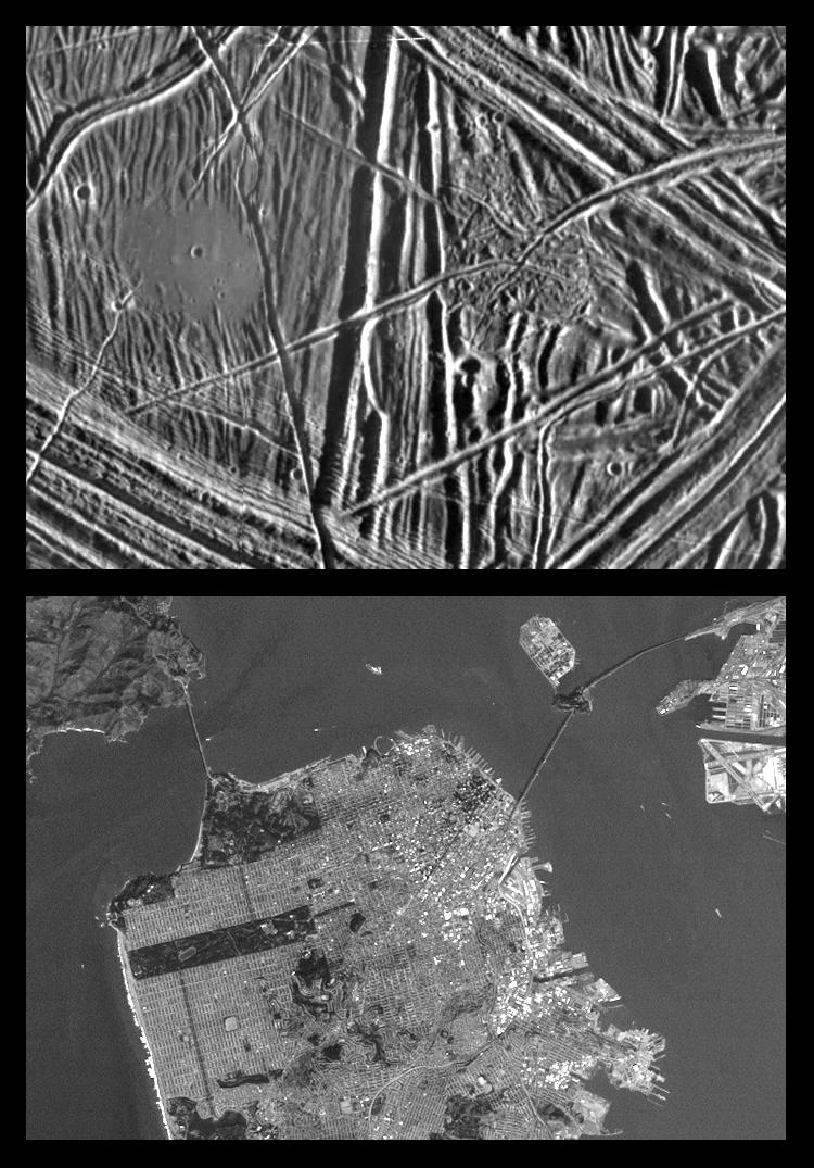
This is the fifth in a series of products at increasing resolutions that compare images of various areas on Jupiter's moon Europa (top frame) to the same location on Earth, the San Francisco Bay area of California (bottom frame). Both images show areas of equal size, 13 by 18 kilometers (8 by 11 miles), and resolution, 26 meters (28 yards). North is to the top of the picture.
In this close-up view of Europa's icy surface, a flat smooth area about 3.2 kilometers (2 miles) across is seen in the left part of the picture. This area resulted from flooding by a fluid which erupted onto the surface and buried sets of ridges and grooves. The smooth area contrasts with a distinctly rugged patch of terrain farther east, to the right of the prominent ridge system running down the middle of the picture. Eruptions of material onto the surface, crustal disruption, and the formation of complex networks of folded and faulted ridges show that significant energy was available in the interior of Europa. The Sun illuminates the scene from the east (right).
The San Francisco Bay area image helps to give a sense of scale to the predominant features in the Europa image above. Both the "flat smooth area" and the contrasting "rugged patch" are sufficiently large to cover all of downtown San Francisco. The Golden Gate Bridge, if on Europa's surface, would be long enough to span each of those features as well.
The Europa image was obtained from a range of 2500 kilometers (1600 miles) by the Solid State Imaging (CCD) system aboard NASA's Galileo spacecraft on December 19th, 1996 (Universal Time). The San Francisco Bay area image, from the LandSat Thematic Mapper, has been reprocessed to match Galileo's resolution so as to offer a sense of the size of the features visible on Europa's surface.
The Jet Propulsion Laboratory, Pasadena, CA manages the mission for NASA's Office of Space Science, Washington, DC.
This image and other images and data received from Galileo are posted on the World Wide Web, on the Galileo mission home page at URL http://galileo.jpl.nasa.gov. Background information and educational context for the images can be found at http://www.jpl.nasa.gov/galileo/sepo.
 Planetary Data System


