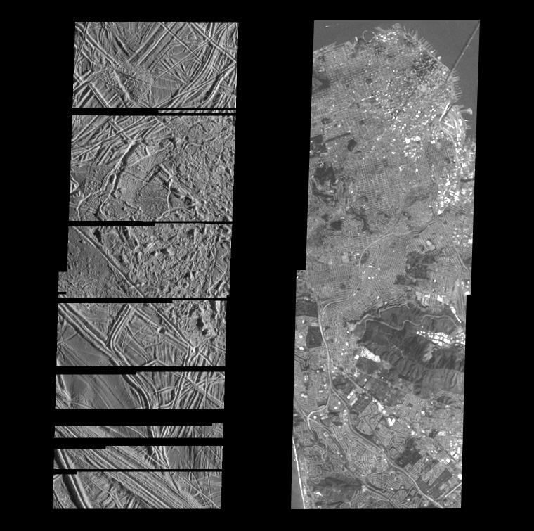
This is the fourth in a series of five products at increasing resolutions that compare images of various areas on Jupiter's icy moon Europa (left frame) to the same location on Earth, the San Francisco Bay area of California (right frame). Both images show areas of equal size, 17 by 49 kilometers (11 by 30 miles), and resolution, 30 meters (100 feet). North is to the top of the picture.
The frame on the left is a mosaic of two images of Europa and shows the surface to be structurally complex. The sun illuminates the scene from the east, revealing complex overlapping ridges and fractures in the upper and lower portions of the frame, and rugged, more chaotic terrain in the center. Lateral faulting is revealed where ridges show offsets along their lengths (upper left of the frame). Missing ridge segments indicate obliteration of pre-existing materials and emplacement of new terrain (center of the frame).
The surface of San Francisco rivals that of Europa. In this 30 meter resolution comparison image, the complex pattern of city streets is clearly visible as are the many piers that line the water front district (upper right). This Bay area scene is also illuminated from the east. Notice the shadow of the Bay Bridge on the surface of the water as it makes its way to Oakland and the east bay. In the upper left corner, a ship can be seen making its way to the mouth of the bay.
The Europa image was obtained from a range of 3410 kilometers (2119 miles) by the Solid State Imaging (CCD) system aboard NASA's Galileo spacecraft on December 19th, 1996 (Universal Time). The San Francisco Bay area image, from the LandSat Thematic Mapper, has been reprocessed to match Galileo's resolution so as to offer a sense of the size of the features visible on Europa's surface.
The Jet Propulsion Laboratory, Pasadena, CA manages the mission for NASA's Office of Space Science, Washington, DC. This image and other images and data received from Galileo are posted on the World Wide Web, on the Galileo mission home page at URL http://galileo.jpl.nasa.gov. Background information and educational context for the images can be found at http://www.jpl.nasa.gov/galileo/sepo.
 Planetary Data System


