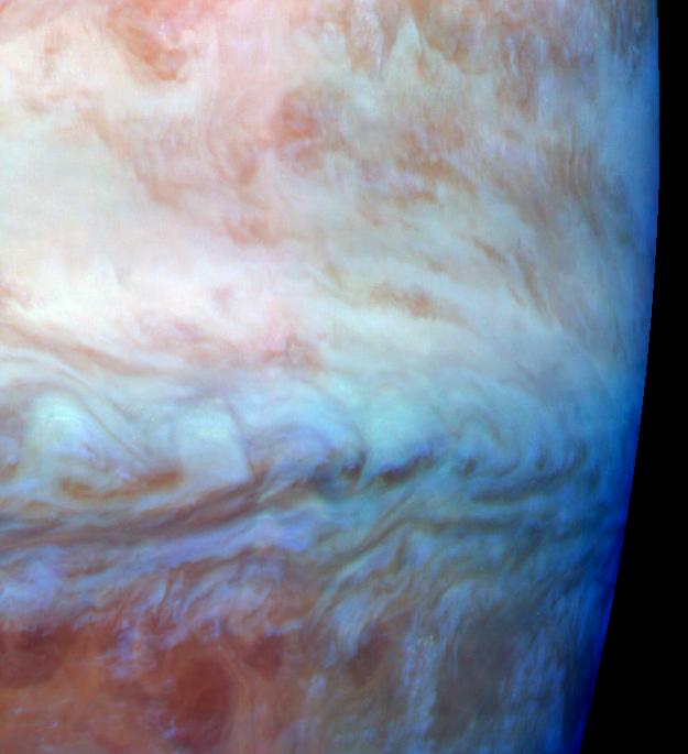
This false color mosaic shows a belt-zone boundary near Jupiter's equator. The images that make up the four quadrants of this mosaic were taken within a few minutes of each other. Light at each of Galileo's three near-infrared wavelengths is displayed here in the visible colors red, green and blue. Light at 886 nanometers, strongly absorbed by atmospheric methane and scattered from clouds high in the atmosphere, is shown in red. Light at 732 nanometers, moderately absorbed by atmospheric methane, is shown in green. Light at 757 nanometers, scattered mostly from Jupiter's lower visible cloud deck, is shown in blue. The lower cloud deck appears bluish white, while the higher layer appears pinkish. The holes in the upper layer and their relationships to features in the lower cloud deck can be studied in the lower half of the mosaic. Galileo is the first spacecraft to image different layers in Jupiter's atmosphere.
The edge of the planet runs along the right side of the mosaic. North is at the top. The mosaic covers latitudes -13 to +3 degrees and is centered at longitude 280 degrees west. The smallest resolved features are tens of kilometers in size. These images were taken on Nov. 5, 1996, at a range of 1.2 million kilometers by the solid state imaging (CCD) system aboard NASA's Galileo spacecraft.
Launched in October 1989, Galileo entered orbit around Jupiter on Dec. 7, 1995. The spacecraft's mission is to conduct detailed studies of the giant planet, its largest moons and the Jovian magnetic environment. The Jet Propulsion Laboratory, Pasadena, CA, manages the mission for NASA's Office of Space Science, Washington, DC.
This image and other images and data received from Galileo are posted on the World Wide Web Galileo mission home page at http://galileo.jpl.nasa.gov. Background information and educational context for the images can be found at http://www.jpl.nasa.gov/galileo/sepo.
 Planetary Data System


