PDS logoPlanetary Data System
PDS Information
Find a Node - Use these links to navigate to any of the 8 publicly accessible PDS Nodes.

This bar indicates that you are within the PDS enterprise which includes 6 science discipline nodes and 2 support nodes which are overseen by the Project Management Office at NASA's Goddard Space Flight Center (GSFC). Each node is led by an expert in the subject discipline, supported by an advisory group of other practitioners of that discipline, and subject to selection and approval under a regular NASA Research Announcement.
Click here to return to the Photojournal Home Page Click here to view a list of Photojournal Image Galleries Photojournal_inner_header
Latest Images  |  Spacecraft & Technology  |  Animations  |  Space Images App  |  Feedback  |  Photojournal Search  

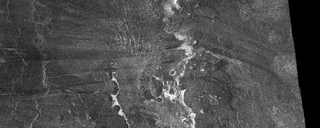
PIA00483: Venus - Outflow Channel in South Navka
 Target Name:  Venus
 Is a satellite of:  Sol (our sun)
 Mission:  Magellan
 Spacecraft:  Magellan
 Instrument:  Imaging Radar
 Product Size:  2560 x 1024 pixels (w x h)
 Produced By:  JPL
 Producer ID:  P37131
 Addition Date:  1996-11-14
 Primary Data Set:  Magellan MIDRs
 Full-Res TIFF:  PIA00483.tif (2.171 MB)
 Full-Res JPEG:  PIA00483.jpg (825.6 kB)

Click on the image above to download a moderately sized image in JPEG format (possibly reduced in size from original)

Original Caption Released with Image:

This SAR image from the southern portion of Navka (24.4-25.3 degrees south latitude, 338.5-340.5 degrees east longitude) is a mosaic of twelve Magellan orbits that covers 180 kilometers (108 miles) in width and 78 kilometers (47 miles) in length. In the center of this image are two bright deposits running north to south. These deposits outline an outflow channel that flowed from a 60-km diameter crater that is to the south of the channel. Inside the outflow channel and outlined by 'bathtub ring' deposits are small cones, most likely of volcanic origin. At the end of the outflow channel, where one would expect the smallest particles to be deposited, are specular features which may represent sand dunes. Seasat and space shuttle radar images of sand dunes on Earth also show specular reflections from smooth dune faces that are near-normal to the radar beam. Other evidence for aeolian activity are the dark and bright windstreaks running east to west that form behind cones. Notice how the wind changes direction from a southeast-northwest flow at the right of the image to an east-west flow at the eastern edge of the outflow channel.

Image Credit:
NASA/JPL

Image Addition Date:
1996-11-14