PDS logoPlanetary Data System
PDS Information
Find a Node - Use these links to navigate to any of the 8 publicly accessible PDS Nodes.

This bar indicates that you are within the PDS enterprise which includes 6 science discipline nodes and 2 support nodes which are overseen by the Project Management Office at NASA's Goddard Space Flight Center (GSFC). Each node is led by an expert in the subject discipline, supported by an advisory group of other practitioners of that discipline, and subject to selection and approval under a regular NASA Research Announcement.
Click here to return to the Photojournal Home Page Click here to view a list of Photojournal Image Galleries Photojournal_inner_header
Latest Images  |  Spacecraft & Technology  |  Animations  |  Space Images App  |  Feedback  |  Photojournal Search  

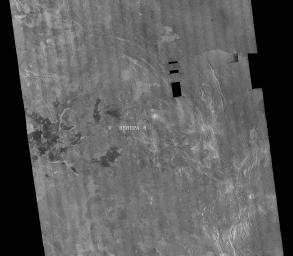
PIA00460: Venus - Venera 8 Landing Site in Navka Region
 Target Name:  Venus
 Is a satellite of:  Sol (our sun)
 Mission:  Magellan
 Spacecraft:  Magellan
 Instrument:  Imaging Radar
 Product Size:  8192 x 7168 pixels (w x h)
 Produced By:  JPL
 Producer ID:  P36909
 Addition Date:  1996-09-26
 Primary Data Set:  Magellan MIDRs
 Full-Res TIFF:  PIA00460.tif (45.16 MB)
 Full-Res JPEG:  PIA00460.jpg (17.72 MB)

Click on the image above to download a moderately sized image in JPEG format (possibly reduced in size from original)

Original Caption Released with Image:

This image is a mosaic of 24 orbits of the Navka region of Venus. The image is centered at about 10 degrees south latitude and 335 degrees east longitude. The image is about 400 km (240 miles) across. 'Behepa 8' marks the approximate landing site of the Soviet Venera 8 lander, which took measurements at the surface of Venus in 1972. The Venera 8 lander measured granitic or continental-like materials at the landing site. Magellan data reveals the landing site to lie in a region of plains cut by tectonic ridges and troughs. Volcanic domes and flows are seen throughout the region. Studying the regional setting of the Venera landing sites is important in linking information about surface composition to surface morphology seen in radar images. Resolution of the Magellan data is about 120 meters (400 feet).

Image Credit:
NASA/JPL

Image Addition Date:
1996-09-26