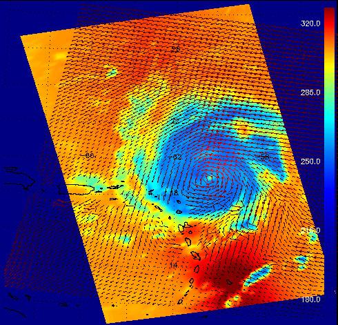
This image shows Hurricane Frances as captured by instruments onboard two different satellites: the AIRS infrared instrument onboard Aqua, and the SeaWinds scatterometer onboard QuikSCAT. Both are JPL-managed instruments. AIRS data are used to create global three-dimensional maps of temperature, humidity and clouds, while scatterometers measure surface wind speed and direction over the ocean.
The red vectors in the image show Frances' surface winds as measured by SeaWinds on QuikSCAT. The background colors show the temperature of clouds and surface as viewed in the infrared by AIRS, with cooler areas pushing to purple and warmer areas are pushing to red. The color scale on the right gives the temperatures in degrees Kelvin. (The top of the scale, 320 degrees Kelvin, corresponds to 117 degrees Fahrenheit, and the bottom, 180 degrees K is -135 degrees F.) The powerful circulation of this storm is evident from the combined data as well as the development of a clearly-defined central "eye." The infrared signal does not penetrate through clouds, so the light blue areas reveal the cold clouds tops associated with strong thunderstorms embedded within the storm. In cloud-free areas the infrared signal comes from Earth's surface, revealing warmer temperatures.
The power of the SeaWinds scatterometer data set lies in its ability to generate global maps of wind speed and direction, giving us a snapshot of how the atmosphere is circulating. Weather prediction centers, including the Tropical Prediction Center - a branch of NOAA that monitors the creation of ocean-born storms, use scatterometer data to help it "see" where these storms are brewing so that warnings can be issued and the storms, with often erratic motions, can be tracked.
While the SeaWinds instrument isn't designed to gather hurricane data, having difficulty seeing the surface in heavy rain, it's data can be used in combination with other data sets to give us an insight into these storms. In this combination image, the AIRS infrared data reveals the temperature of the atmosphere around the storm, but doesn't tell us about the wind direction or relative intensity. The directional vectors of the SeaWinds data set show how the air is circulating around the storm.
Scatterometers measure surface wind speed and direction by bouncing microwave pulses off the ocean's surface. The SeaWinds instruments measure the backscattered radar energy from wind-generated ocean waves. By making multiple measurements from different looks at the same location, we can infer the vector wind averaged over each 25 km resolution cell. The primary mission objective of the SeaWinds and QuikSCAT scatterometers is to obtain long-term, global coverage of the ocean vector winds for oceanographic and climate research. While not specifically designed for detailed mapping and tracking of hurricanes, both instruments have been found to be useful resources for operational forecasters.
About AIRS
The Atmospheric Infrared Sounder, AIRS, in conjunction with the Advanced Microwave Sounding Unit, AMSU, senses emitted infrared and microwave radiation from Earth to provide a three-dimensional look at Earth's weather and climate. Working in tandem, the two instruments make simultaneous observations all the way down to Earth's surface, even in the presence of heavy clouds. With more than 2,000 channels sensing different regions of the atmosphere, the system creates a global, three-dimensional map of atmospheric temperature and humidity, cloud amounts and heights, greenhouse gas concentrations, and many other atmospheric phenomena. Launched into Earth orbit in 2002, the AIRS and AMSU instruments fly onboard NASA's Aqua spacecraft and are managed by NASA's Jet Propulsion Laboratory in Pasadena, Calif., under contract to NASA. JPL is a division of the California Institute of Technology in Pasadena.
More information about AIRS can be found at http://airs.jpl.nasa.gov.