 |  |
| Figure 1: Microwave 89Ghz image | Figure 2: Visible/near infrared sensor |
Hurricane Ivan is the most powerful hurricane to hit the Caribbean in 10 years. On September 7 and 8 it damaged 90 percent of the homes in Grenada and killed at least 16 people as it swept over Grenada, Barbados and the other islands in the area. By Thursday morning on September 9, Ivan's sustained winds reached 160 mph making it a rare category 5 hurricane on the Saffir-Simpson scale. By Monday September 13, Ivan is blamed for 67 deaths and skirts western Cuba with winds clocked at 156 mph. The National Hurricane Center predicted the eye of Ivan will make landfall across Mobile Bay in Alabama late Wednesday or early Thursday.
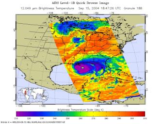
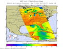
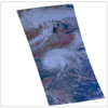
These images of Hurricane Ivan were acquired by the AIRS infrared, microwave, and visible sensors on September 15 at 1:30 pm local time as the storm moves in to Alabama. Ivan at category 4 strength is about 150 miles south of Mobile, Alabama and is moving north at 14 mph. Maximum sustained winds are reported to be at 135 mph and extend 105 miles from the center, while tropical storm-force winds extend 290 miles from the center. Ivan pounded the Gulf coast all day Wednesday, and is expected to make landfall between midnight and 3am in Mobile Bay, Alabama.
This image shows how the storm looks through an AIRS Infrared window channel, and reveals a very large eye - about 75 km (50 miles) across. Window channels measure the temperature of the cloud tops or the surface of the Earth in cloud-free regions. The lowest temperatures are associated with high, cold cloud tops that make up the top of the hurricane. The infrared signal does not penetrate through clouds, so the purple color indicates the cool cloud tops of the storm. In cloud-free areas, the infrared signal is retrieved at the Earth's surface, revealing warmer temperatures. Cooler areas are pushing to purple and warmer areas are pushing to red.
The microwave image (figure 2) reveals where the heaviest precipitation in Ivan is taking place. The blue areas within the storm show the location of this heavy precipitation. Blue areas outside of the storm where there are moderate or no clouds are where the cold (in the microwave sense) sea surface shines through. The image shows that the largest area of intense convection/precipitation is in the NE quadrant, centered near New Orleans. There is a smaller but still quite intense area in the SE quadrant trailing the center of the storm that might impact the Alabama coast.
Image Journal
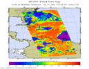
September 7, Tuesday, 1:30 am. - infrared, 12micron
The infrared signal does not penetrate through clouds, so the purple color reveals the cool cloud tops of the hurricane. In cloud-free areas, the infrared signal is retrieved at the Earth's surface, revealing warmer temperatures. Ivan becomes better organized as it approaches the Windward Islands. The center of the storm is 170 miles (275 km) southeast of Barbados and moving west at 21 mph (33 km/hr). Maximum sustained winds near 105 mph which extend outward at this force for 70 miles (110 km).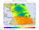
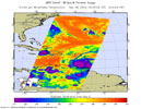
September 7, Tuesday, 1:30 am. - microwave, 89GHz
September 8, Wednesday, 1:30 am. - infrared, 12micron
The infrared signal does not penetrate through clouds, so the purple color reveals the cool cloud tops of the hurricane. In cloud-free areas, the infrared signal is retrieved at the Earth's surface, revealing warmer temperatures. Ivan becomes better organized as it approaches the Windward Islands. The center of the storm is 170 miles (275 km) southeast of Barbados and moving west at 21 mph (33 km/hr). Maximum sustained winds near 105 mph which extend outward at this force for 70 miles (110 km).
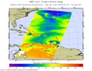
September 8, Wednesday, 1:30 am. - microwave, 89GHz
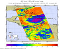 September 10, Friday, 1:30 pm. - infrared, 12micron
Ivan closes in on Jamaica. With only 85 miles between the storm and the island, Ivan's winds at category 4 are sustained at 145 mph (230 km/hr). Hurricane-strength winds extend up to 60 miles from the center of Ivan, and tropical-storm force winds are up to 175 miles from the center. Ivan is now better organized and has a well-defined eye. After Ivan leaves Jamaica, it is expected to hit western Cuba, probably making landfall later Sunday as a CAT 4 hurricane.
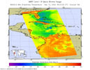
September 10, Friday, 1:30 pm. - microwave, 89GHz
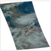
September 10, Friday, 1:30 pm. - visible/near-infrared
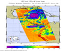
September 13, Friday, 1:30 pm. - infrared, 12micron
Ivan's winds at category 5 strength are sustained at 160 mph (260 km/hr) and extend out to 105 miles from the center. Tropical-storm force winds are up to 205 miles from the center. The infrared image shows that the eye has grown quite large - perhaps 40 km (25 miles) across - which is sometimes an indication of weakening but may not be in this case. The surface pressure at the time of this image was estimated by the National Hurricane Center at 915 mb and falling - consistent with a very intense and strengthening hurricane.
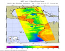
September 13, Friday, 1:30 pm. - microwave, 89GHz
The microwave image shows that Ivan has again developed two distinct convective centers, separated by about 250 km. That pattern developed on September 5 and persisted for 4 days. It disappeared while the storm was passing over Jamaica, but it has now re-formed.
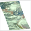
September 13, Friday, 1:30 pm. - visible/near-infrared.
About AIRS
The Atmospheric Infrared Sounder, AIRS, in conjunction with the Advanced Microwave Sounding Unit, AMSU, senses emitted infrared and microwave radiation from Earth to provide a three-dimensional look at Earth's weather and climate. Working in tandem, the two instruments make simultaneous observations all the way down to Earth's surface, even in the presence of heavy clouds. With more than 2,000 channels sensing different regions of the atmosphere, the system creates a global, three-dimensional map of atmospheric temperature and humidity, cloud amounts and heights, greenhouse gas concentrations, and many other atmospheric phenomena. Launched into Earth orbit in 2002, the AIRS and AMSU instruments fly onboard NASA's Aqua spacecraft and are managed by NASA's Jet Propulsion Laboratory in Pasadena, Calif., under contract to NASA. JPL is a division of the California Institute of Technology in Pasadena.
More information about AIRS can be found at http://airs.jpl.nasa.gov.

 Planetary Data System


