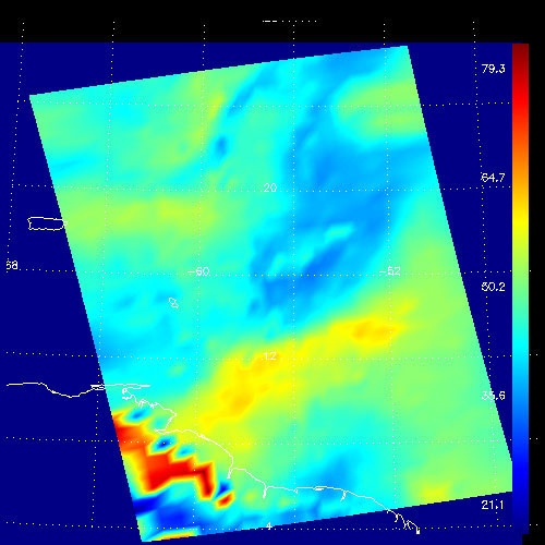
Figure 1These false-color images show the amount of atmospheric water vapor observed by AIRS two weeks prior to the passage of Hurricane Isabel, and then when it was a Category 5 storm. The region shown includes parts of South America and the West Indies. Puerto Rico is the large island below the upper left corner.
Total water vapor represents the depth of a layer if all the water vapor in the atmosphere were to condense and fall to the surface. The color bar on the right sides of the plots give the thickness of this layer in millimeters (mm). The first image, from August 28, shows typical tropical water vapor amounts over the ocean: between roughly 25 and 50 mm, or 1 to 2 inches. The highest values of roughly 80 mm, seen as a red blob over South America, corresponds to intense thunderstorms. Thunderstorms pull in water vapor from surrounding regions and concentrate it, with much of it then falling as rain.
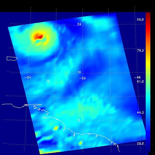
Figure 1 shows total water during the passage of Hurricane Isabel on September 13. The storm is apparent: the ring of moderate values surrounding a very strong maximum of 100 mm. Total water of more than 80 mm is unusual, and these values correspond to the intense thunderstorms contained within Isabel. The thunderstorms--and the large values of total water--are fed by evaporation from the ocean in the hurricane's high winds. The water vapor near the center of the storm does not remain there long, since hurricane rain rates as high 50 mm (2 inches) per hour imply rapid cycling of the water we observe. Away from the storm the amount of total water vapor is rather low, associated with fair weather where air that ascended near the storm's eye returns to earth, having dropped its moisture as rain. Also seen in the second images are two small regions of about 70 mm of total water over south America. These are yet more thunderstorms, though likely much more benign than those in Isabel.
About AIRS
The Atmospheric Infrared Sounder, AIRS, in conjunction with the Advanced Microwave Sounding Unit, AMSU, senses emitted infrared and microwave radiation from Earth to provide a three-dimensional look at Earth's weather and climate. Working in tandem, the two instruments make simultaneous observations all the way down to Earth's surface, even in the presence of heavy clouds. With more than 2,000 channels sensing different regions of the atmosphere, the system creates a global, three-dimensional map of atmospheric temperature and humidity, cloud amounts and heights, greenhouse gas concentrations, and many other atmospheric phenomena. Launched into Earth orbit in 2002, the AIRS and AMSU instruments fly onboard NASA's Aqua spacecraft and are managed by NASA's Jet Propulsion Laboratory in Pasadena, Calif., under contract to NASA. JPL is a division of the California Institute of Technology in Pasadena.
More information about AIRS can be found at http://airs.jpl.nasa.gov.
