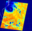
Figure 1: AIRS infrared channel 2333 (2616 cm-1)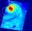
Figure 2: Total Water Vapor retrieved from AIRS infrared and AMSU-A microwave dataSeptember 18, 2003
These two false-color images show Hurricane Isabel viewed by the AIRS and AMSU-A instruments at 1:30 EDT in the morning of Thursday September 18, 2003. Isabel will be ashore within 12 hours, bringing widespread flooding and destructive winds. In figure 1 on the left, data retrieved by the AIRS infrared sensor shows the hurricane's eye as the small ring of pale blue near the upper left corner of the image. The dark blue band around the eye shows the cold tops of hundreds of powerful thunderstorms. These storms are embedded in the 120 mile per hour winds swirling counterclockwise around Isabel's eye. Cape Hatteras is the finger of land north-northwest of the eye. Isabel's winds will soon push ashore a 4- to 8-foot high mound of 'storm surge' and accompanying high surf, leading to flooding of Cape Hatteras and other islands of North Carolina's Outer Banks. Also seen in the image are several organized bands of cold, (blue) thunderstorm tops being pulled into the storm center. Other thunderstorm are forming north of the islands of Jamaica, Cuba, Hispaniola and Puerto Rico near the bottom of the picture.
Figure 2 shows the geographical distribution and total amount of atmospheric water vapor associated with Isabel as inferred by AIRS and AMSU-A. Very humid areas appear deep red and surround the storm's eye in the ring of thunderstorms, as seen above. The enhancement of atmospheric water vapor in the storm is maintained by evaporation from the wind-churned sea surface. In turn, the water vapor powers the thunderstorms by condensing as rain and releasing the ocean's warmth into the atmosphere to drive strong convection. This makes Isabel and other hurricanes 'heat engines,' converting ocean water's warmth into atmospheric gales. Isabel is weakening as it move ashore and loses its supply of energy from warm water, but not before raining an expected 6-12 inch thick layer of its water over an area extending from South Carolina and New England to the midwest and southern Canada. Paler blue areas in the water vapor image show less humid heights of the atmosphere, which are associated with the colder thunderstorm tops seen in the infrared image.
About AIRS
The Atmospheric Infrared Sounder, AIRS, in conjunction with the Advanced Microwave Sounding Unit, AMSU, senses emitted infrared and microwave radiation from Earth to provide a three-dimensional look at Earth's weather and climate. Working in tandem, the two instruments make simultaneous observations all the way down to Earth's surface, even in the presence of heavy clouds. With more than 2,000 channels sensing different regions of the atmosphere, the system creates a global, three-dimensional map of atmospheric temperature and humidity, cloud amounts and heights, greenhouse gas concentrations, and many other atmospheric phenomena. Launched into Earth orbit in 2002, the AIRS and AMSU instruments fly onboard NASA's Aqua spacecraft and are managed by NASA's Jet Propulsion Laboratory in Pasadena, Calif., under contract to NASA. JPL is a division of the California Institute of Technology in Pasadena.
More information about AIRS can be found at http://airs.jpl.nasa.gov.
