 |  |
| Figure 1: Vis/NIR Image Closeup | Figure 2: Difference Image |
October 2002
Mt. Etna, a volcano on the island of Sicily, erupted on October 26, 2002. Preliminary analysis of data taken by the Atmospheric Infrared Sounder (AIRS) on NASA's Aqua satellite on October 28 shows the instrument can provide an excellent means to study the evolution and structure of the sulfur dioxide (SO2) plume emitted from volcanoes. These data also demonstrate that AIRS can be used to obtain the total mass of SO2 injected into the atmosphere during a volcanic event, information that may help us to better understand these dangerous natural occurrences in the future.
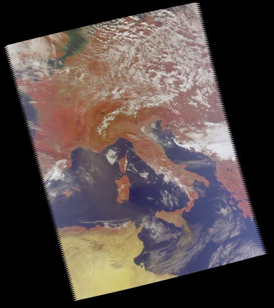
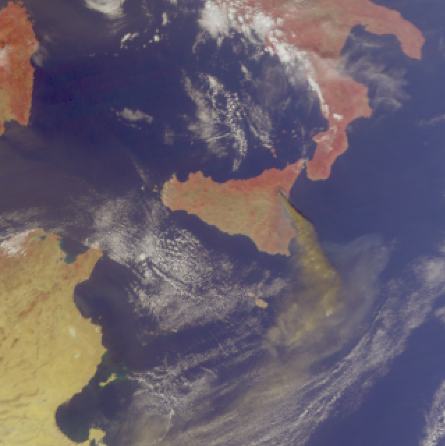
This image was made from a sensor on the AIRS instrument that is sensitive to the visible and near-infrared portions of the spectrum. The visible/near infrared data show the smoke plume from Mt. Etna. The view is of Europe and the central Mediterranean with Italy in the center. Since the visible/near infrared sensor on AIRS is sensitive to wavelengths that are different than the human eye, vegetated regions appear red (compare the red color of Europe with the tan desert of North Africa in the lower left). Figure 1 is a closer view of Sicily and shows a long, brownish smoke plume extending across the Mediterranean to Africa. This is consistent with the enhanced feature in the difference image in Figure 2 and helps validate the information inferred from that image.
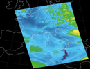
Figure 2 clearly shows the SO2 plume. This image was created by comparing data taken at two different frequencies, or channels, and creating one image that highlights the differences between these two channels. Both channels are sensitive to water vapor, but one of the channels is also sensitive to SO2. By subtracting out the common water vapor signal in both channels, the SO2 feature remains and shows up as an enhancement in the difference image.
About AIRS
The Atmospheric Infrared Sounder, AIRS, in conjunction with the Advanced Microwave Sounding Unit, AMSU, senses emitted infrared and microwave radiation from Earth to provide a three-dimensional look at Earth's weather and climate. Working in tandem, the two instruments make simultaneous observations all the way down to Earth's surface, even in the presence of heavy clouds. With more than 2,000 channels sensing different regions of the atmosphere, the system creates a global, three-dimensional map of atmospheric temperature and humidity, cloud amounts and heights, greenhouse gas concentrations, and many other atmospheric phenomena. Launched into Earth orbit in 2002, the AIRS and AMSU instruments fly onboard NASA's Aqua spacecraft and are managed by NASA's Jet Propulsion Laboratory in Pasadena, Calif., under contract to NASA. JPL is a division of the California Institute of Technology in Pasadena.
More information about AIRS can be found at http://airs.jpl.nasa.gov.
 Planetary Data System


