PDS logoPlanetary Data System
PDS Information
Find a Node - Use these links to navigate to any of the 8 publicly accessible PDS Nodes.

This bar indicates that you are within the PDS enterprise which includes 6 science discipline nodes and 2 support nodes which are overseen by the Project Management Office at NASA's Goddard Space Flight Center (GSFC). Each node is led by an expert in the subject discipline, supported by an advisory group of other practitioners of that discipline, and subject to selection and approval under a regular NASA Research Announcement.
Click here to return to the Photojournal Home Page Click here to view a list of Photojournal Image Galleries Photojournal_inner_header
Latest Images  |  Spacecraft & Technology  |  Animations  |  Space Images App  |  Feedback  |  Photojournal Search  

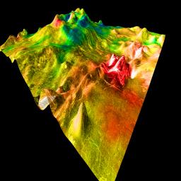
PIA00308: Magellan's Perspective View of Ovda Regio, 15° N, 77° E
 Target Name:  Venus
 Is a satellite of:  Sol (our sun)
 Mission:  Magellan
 Spacecraft:  Magellan
 Instrument:  Imaging Radar
 Product Size:  1500 x 1500 pixels (w x h)
 Produced By:  U.S. Geological Survey
 Addition Date:  1998-06-04
 Primary Data Set:  Magellan MIDRs
 Full-Res TIFF:  PIA00308.tif (3.113 MB)
 Full-Res JPEG:  PIA00308.jpg (469.6 kB)

Click on the image above to download a moderately sized image in JPEG format (possibly reduced in size from original)

Original Caption Released with Image:

This perspective view of Venus, generated by computer from Magellan data and color-coded with emissivity, shows part of the lowlands to the north of Ovda Regio. The prominent topographic feature is a shield volcano, one of many distinct types of volcanic features on Venus. The volcano, with its partially breached summit caldera and central dome, bears a superficial resemblance to Mount St. Helens in this strongly vertically exaggerated view. In reality, it is roughly 700 km across, comparable to Olympus Mons on Mars, although it is only 2 km high. The extremely low, broad shape of the volcano probably results from the eruption of highly fluid lava such as basalt, combined with Venus' high surface temperature. Individual lava flows can be seen on the righthand side of the volcano, which has a slope of less than half a degree. The rugged area at the extreme right is part of a fracture zone that appears to extend under the volcano and may have provided a path by which lava was erupted. The cone-shaped hill in the foreground is an artifact caused by a single erroneous altimeter measurement; its size gives an indication of the horizontal resolution of the altimetry map. Magellan MIDR quadrangle* containing this image: C1-15N077. Image resolution (m): 225. Size of region shown (E-W x N-S, in km): 851 x 878. Range of emissivities from violet to red: 0.74 -- 0.84. Vertical exaggeration: 100. Azimuth of viewpoint (deg clockwise from East): 135. Elevation of viewpoint (km): 300. *Quadrangle name indicates approximate center latitude (N=north, S=south) and center longitude (East).

Image Credit:
NASA/JPL/USGS

Image Addition Date:
1998-06-04